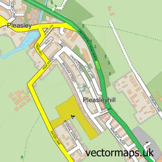
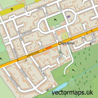
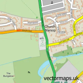
This Mansfield Woodhouse street map is a detailed vector street map covering a 750m x 750m area. Select a larger area to create and download your own vector street map of Mansfield Woodhouse.
The 750-metre map sample for Mansfield Woodhouse covers 515 mapped buildings and approximately 28.4 km of road detail, of which 52 named roads are named. The immediate area includes 3 schools, 1 GP surgery, with 8 within 2 miles, 7 pubs and 2 MOT stations, with 21 within 2 miles. The wider area around Mansfield Woodhouse features 2 tourism points of interest, 14 food and drink venues and 1 campsite within 2 miles. To create a larger or custom map of Mansfield Woodhouse, the map builder lets you define your own coverage area and download editable SVG, PDF and PNG files.
Create a larger editable map of Mansfield Woodhouse
Choose any area you need and generate a high-quality vector map instantly. Perfect for print, planning, design, business and personal use.

This Mansfield Woodhouse street map in Nottinghamshire is available as downloadable SVG, PDF and PNG map files, or as a printed map for planning, business, display, education, local information and design work. You can also create a larger custom map area using the map selector.
What this Mansfield Woodhouse map sample shows
Mansfield Woodhouse lies within Nottinghamshire County parish, part of Yeoman Hill ward in the Mansfield District local authority area. The postcode geography for this area includes the NG postcode area, the NG19 postcode district and the NG19 9 postcode sector. Residents fall under the Nhs Nottingham And Nottinghamshire Integrated Care Board for NHS services.
Local features near Mansfield Woodhouse
Within 2 milesAmenities and services in and around Mansfield Woodhouse.
Administrative and postcode information for Mansfield Woodhouse
Mansfield Woodhouse lies within Nottinghamshire County parish, part of Yeoman Hill ward in the Mansfield District local authority area. The postcode geography for this area includes the NG postcode area, the NG19 postcode district and the NG19 9 postcode sector. Residents fall under the Nhs Nottingham And Nottinghamshire Integrated Care Board for NHS services.
Nearby street map samples around Mansfield Woodhouse

More street maps in Nottinghamshire
750 metre map area coverage
Boundary, postcode and point of interest information for the 750m x 750m rectangle centred on this sample map.
Boundaries containing map centre
Constituency: Mansfield Co Const
County: Nottinghamshire County
District: Mansfield District
Icb: NHS Nottingham and Nottinghamshire ICB
Police Force: nottinghamshire
Postcode District: NG19
Postcode Sector: NG19 8
Ward: Yeoman Hill Ward
Nearby boundaries intersecting sample
Postcode Sector: NG19 9
Ward: Manor Ward, Vale Ward
Postcode coverage
POI category counts
Beauty Salon: 7
Professional Services: 7
Pub: 7
Automotive Repair: 5
Charity Organization: 5
Convenience Store: 4
Flowers And Gifts Shop: 4
It Service And Computer Repair: 4
Package Locker: 4
Restaurant: 4
Sample points of interest
- Brealey & Newbury
- St Edmund's and St Chad's
- Sweet Sheep
- The Two Knits
- ATM (Post Office)
- Payzone
- Priory Road Allotments: Mansfield Woodhouse
- Sell My Car Nottingham
- Nottingham DPF Cleaning
- Park Garage
- Park Garage Mansfield Woodhouse
- Star Garage Mansfield
Create a larger editable map of Mansfield Woodhouse
This sample shows only a 750 metre area. To create a larger map of Mansfield Woodhouse, use our map builder to choose your own coverage area, add titles and download editable SVG, PDF and PNG files.
Create a custom map of Mansfield Woodhouse