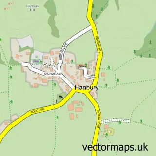
This Marchington street map is a detailed vector street map covering a 750m x 750m area. Select a larger area to create and download your own vector street map of Marchington.
The 750-metre map sample for Marchington covers 217 mapped buildings and approximately 16.5 km of road detail, of which 14 named roads are named. The immediate area includes 1 school and 3 pubs. The wider area around Marchington features 3 food and drink venues. To create a larger or custom map of Marchington, the map builder lets you define your own coverage area and download editable SVG, PDF and PNG files.
Create a larger editable map of Marchington
Choose any area you need and generate a high-quality vector map instantly. Perfect for print, planning, design, business and personal use.

This Marchington street map in Staffordshire is available as downloadable SVG, PDF and PNG map files, or as a printed map for planning, business, display, education, local information and design work. You can also create a larger custom map area using the map selector.
What this Marchington map sample shows
Marchington lies within Marchington Cp parish, part of Crown ward in the East Staffordshire District (B) local authority area. The postcode geography for this area includes the ST postcode area, the ST14 postcode district and the ST14 8 postcode sector. Residents fall under the Nhs Staffordshire And Stoke-On-Trent Integrated Care Board for NHS services.
Local features near Marchington
Within 2 milesAmenities and services in and around Marchington.
Administrative and postcode information for Marchington
The local authority covering Marchington is East Staffordshire District (B), within the county of Staffordshire. The settlement lies within Crown ward and Marchington Cp civil parish. The ST14 postcode district and ST14 8 postcode sector serve the immediate area. NHS provision in the area is delivered through University Hospitals Of Derby And Burton Nhs Foundation Trust.
Nearby street map samples around Marchington

More street maps in Staffordshire
750 metre map area coverage
Boundary, postcode and point of interest information for the 750m x 750m rectangle centred on this sample map.
Boundaries containing map centre
Constituency: Burton and Uttoxeter Co Const
County: Staffordshire County
District: East Staffordshire District (B)
Icb: NHS Staffordshire and Stoke-on-Trent ICB
Parish: Marchington CP
Police Force: staffordshire
Postcode District: ST14
Postcode Sector: ST14 8
Ward: Crown Ward
Nearby boundaries intersecting sample
No additional intersecting boundaries found.
Postcode coverage
POI category counts
Pub: 3
Agricultural Service: 1
Church Cathedral: 1
Community Center: 1
Community Services Non Profits: 1
Cricket Ground: 1
Food Beverage Service Distribution: 1
Handyman: 1
Lighting Store: 1
Naturopathic Holistic: 1
Sample points of interest
- The Silage Consultant
- St Peter's Church, Marchington
- Marchington Village Hall
- Marchington Community Shop
- Uttoxeter Cricket Club
- Soiree Food
- RS Handy Man
- Lyon Lighting
- Thrive Hypnotherapy
- J A Kenny Plastering
- 3 Arrows Plumbing and Electrical
- Post Office
Create a larger editable map of Marchington
This sample shows only a 750 metre area. To create a larger map of Marchington, use our map builder to choose your own coverage area, add titles and download editable SVG, PDF and PNG files.
Create a custom map of Marchington