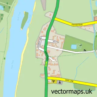
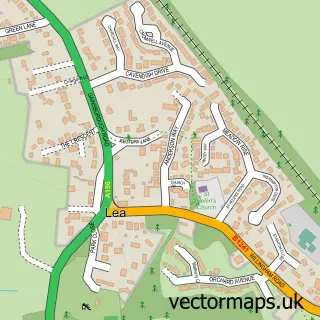
This Marton street map is a detailed vector street map covering a 750m x 750m area. Select a larger area to create and download your own vector street map of Marton.
The 750-metre map sample for Marton covers 241 mapped buildings and approximately 13.0 km of road detail, of which 15 named roads are named. The immediate area includes 1 school, 1 pub and 1 MOT station. The wider area around Marton features 1 food and drink venue. To create a larger or custom map of Marton, the map builder lets you define your own coverage area and download editable SVG, PDF and PNG files.
Create a larger editable map of Marton
Choose any area you need and generate a high-quality vector map instantly. Perfect for print, planning, design, business and personal use.

This Marton street map in Lincolnshire is available as downloadable SVG, PDF and PNG map files, or as a printed map for planning, business, display, education, local information and design work. You can also create a larger custom map area using the map selector.
What this Marton map sample shows
Marton lies within Marton Cp parish, part of Torksey ward in the West Lindsey District local authority area. The postcode geography for this area includes the DN postcode area, the DN21 postcode district and the DN21 5 postcode sector. Residents fall under the Nhs Lincolnshire Integrated Care Board for NHS services.
Local features near Marton
Within 2 milesAmenities and services in and around Marton.
Administrative and postcode information for Marton
Marton lies within Marton Cp parish, part of Torksey ward in the West Lindsey District local authority area. The postcode geography for this area includes the DN postcode area, the DN21 postcode district and the DN21 5 postcode sector. Residents fall under the Nhs Lincolnshire Integrated Care Board for NHS services.
Nearby street map samples around Marton


More street maps in Lincolnshire
750 metre map area coverage
Boundary, postcode and point of interest information for the 750m x 750m rectangle centred on this sample map.
Boundaries containing map centre
Constituency: Gainsborough Co Const
County: Lincolnshire County
District: West Lindsey District
Icb: NHS Lincolnshire ICB
Parish: Marton CP
Police Force: lincolnshire
Postcode District: DN21
Postcode Sector: DN21 5
Ward: Torksey Ward
Nearby boundaries intersecting sample
Parish: Gate Burton CP
Postcode coverage
POI category counts
Bed And Breakfast: 2
Church Cathedral: 2
Convenience Store: 2
Anglican Church: 1
Automotive Repair: 1
Community Center: 1
Doctor: 1
Elementary School: 1
Engineering Services: 1
Home Service: 1
Sample points of interest
- St Margaret
- North End Garage
- Black Swan Guest House
- Black Swan Guest House
- Marton Methodist Chapel
- St. Margaret of Antioch
- Marton and Gate Burton Village Hall
- Londis
- Premier Stores Sturton
- Marton Branch Surgery
- Marton primary school
- Euro Pat Test
Create a larger editable map of Marton
This sample shows only a 750 metre area. To create a larger map of Marton, use our map builder to choose your own coverage area, add titles and download editable SVG, PDF and PNG files.
Create a custom map of Marton