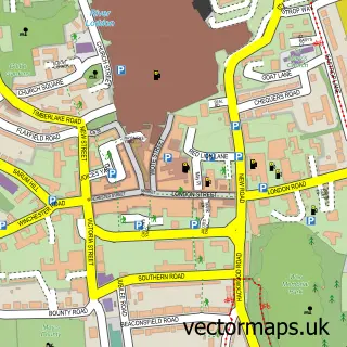
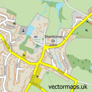
This Old Basing street map is a detailed vector street map covering a 750m x 750m area. Select a larger area to create and download your own vector street map of Old Basing.
The 750-metre map sample for Old Basing covers 344 mapped buildings and approximately 11.5 km of road detail, of which 24 named roads are named. The immediate area includes 2 schools, 4 GP surgeries within 2 miles, 1 pub and 9 MOT stations within 2 miles. The wider area around Old Basing features 1 tourism point of interest and 2 food and drink venues. To create a larger or custom map of Old Basing, the map builder lets you define your own coverage area and download editable SVG, PDF and PNG files.
Create a larger editable map of Old Basing
Choose any area you need and generate a high-quality vector map instantly. Perfect for print, planning, design, business and personal use.

This Old Basing street map in Hampshire is available as downloadable SVG, PDF and PNG map files, or as a printed map for planning, business, display, education, local information and design work. You can also create a larger custom map area using the map selector.
What this Old Basing map sample shows
Old Basing lies within Old Basing And Lychpit Cp parish, part of Basing ward in the Basingstoke And Deane District (B) local authority area. The postcode geography for this area includes the RG postcode area, the RG24 postcode district and the RG24 7 postcode sector. Residents fall under the Nhs Hampshire And Isle Of Wight Integrated Care Board for NHS services.
Local features near Old Basing
Within 2 milesAmenities and services in and around Old Basing.
Administrative and postcode information for Old Basing
Old Basing lies within Old Basing And Lychpit Cp parish, part of Basing ward in the Basingstoke And Deane District (B) local authority area. The postcode geography for this area includes the RG postcode area, the RG24 postcode district and the RG24 7 postcode sector. Residents fall under the Nhs Hampshire And Isle Of Wight Integrated Care Board for NHS services.
Nearby street map samples around Old Basing


More street maps in Hampshire
750 metre map area coverage
Boundary, postcode and point of interest information for the 750m x 750m rectangle centred on this sample map.
Boundaries containing map centre
Constituency: North East Hampshire Co Const
County: Hampshire County
District: Basingstoke and Deane District (B)
Icb: NHS Hampshire and Isle of Wight ICB
Parish: Old Basing and Lychpit CP
Police Force: hampshire
Postcode District: RG24
Postcode Sector: RG24 7
Ward: Basing & Upton Grey Ward
Nearby boundaries intersecting sample
Postcode Sector: RG24 8
Postcode coverage
POI category counts
Church Cathedral: 2
Electronics: 2
Elementary School: 2
Flowers And Gifts Shop: 2
Martial Arts Club: 2
Professional Services: 2
Anglican Church: 1
Bakery: 1
Beauty Salon: 1
Building Contractor: 1
Sample points of interest
- St Mary's
- The Street Bakeshop
- The Topiary Salon
- Alldoors Security Systems
- The Village Cafe Old Basing
- The Bakehouse
- St Mary C of E Church
- St Mary's, Old Basing and Lychpit
- Daqs
- The Old Basing Health Centre
- Murraylectrics
- Servio Technology Limited
Create a larger editable map of Old Basing
This sample shows only a 750 metre area. To create a larger map of Old Basing, use our map builder to choose your own coverage area, add titles and download editable SVG, PDF and PNG files.
Create a custom map of Old Basing