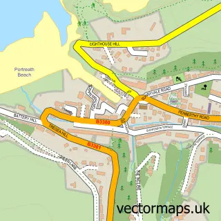
This Porthtowan street map is a detailed vector street map covering a 750m x 750m area. Select a larger area to create and download your own vector street map of Porthtowan.
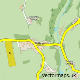
The 750-metre map sample for Porthtowan covers 143 mapped buildings and approximately 11.7 km of road detail, of which 12 named roads are named. The immediate area includes 1 pub and 1 MOT station within 2 miles. The wider area around Porthtowan features 4 food and drink venues, 3 hotels and 6 campsites within 2 miles. To create a larger or custom map of Porthtowan, the map builder lets you define your own coverage area and download editable SVG, PDF and PNG files.
Create a larger editable map of Porthtowan
Choose any area you need and generate a high-quality vector map instantly. Perfect for print, planning, design, business and personal use.

This Porthtowan street map in Cornwall is available as downloadable SVG, PDF and PNG map files, or as a printed map for planning, business, display, education, local information and design work. You can also create a larger custom map area using the map selector.
What this Porthtowan map sample shows
Porthtowan lies within St. Agnes Cp parish, part of Mount Hawke And Portreath ward in the Cornwall local authority area. The postcode geography for this area includes the TR postcode area, the TR4 postcode district and the TR4 8 postcode sector. Residents fall under the Nhs Cornwall And The Isles Of Scilly Integrated Care Board for NHS services.
Local features near Porthtowan
Within 2 milesAmenities and services in and around Porthtowan.
Administrative and postcode information for Porthtowan
Porthtowan lies within St. Agnes Cp parish, part of Mount Hawke And Portreath ward in the Cornwall local authority area. The postcode geography for this area includes the TR postcode area, the TR4 postcode district and the TR4 8 postcode sector. Residents fall under the Nhs Cornwall And The Isles Of Scilly Integrated Care Board for NHS services.
Nearby street map samples around Porthtowan

More street maps in Cornwall
750 metre map area coverage
Boundary, postcode and point of interest information for the 750m x 750m rectangle centred on this sample map.
Boundaries containing map centre
Constituency: Camborne and Redruth Co Const
District: Cornwall
Icb: NHS Cornwall and the Isles of Scilly ICB
Parish: St. Agnes CP
Police Force: devon and cornwall
Postcode District: TR4
Postcode Sector: TR4 8
Nearby boundaries intersecting sample
No additional intersecting boundaries found.
Postcode coverage
POI category counts
Holiday Rental Home: 3
Hotel: 3
Auto Electrical Repair: 2
Beach: 2
Restaurant: 2
Shipping Center: 2
Accommodation: 1
Bar: 1
Beauty Product Supplier: 1
Beauty Salon: 1
Sample points of interest
- Just Beachy Porthtowan
- Mid & West Midland Television Services
- Mid & West Tv Services
- Blue Bar
- Beach Road
- Porthtowan Beach
- Beauty By The Beach
- Forgetmeknot Hair Salon
- VentureSail
- Beach Cafe Porthtowan
- Porthtowan Village Hall
- Porthtowan Village Stores
Create a larger editable map of Porthtowan
This sample shows only a 750 metre area. To create a larger map of Porthtowan, use our map builder to choose your own coverage area, add titles and download editable SVG, PDF and PNG files.
Create a custom map of Porthtowan