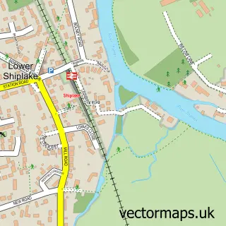
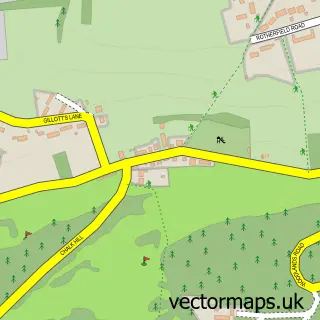
This Shiplake street map is a detailed vector street map covering a 750m x 750m area. Select a larger area to create and download your own vector street map of Shiplake.
The 750-metre map sample for Shiplake covers 154 mapped buildings and approximately 8.3 km of road detail, of which 5 named roads are named. The immediate area includes 1 school, 2 GP surgeries within 2 miles, 1 pub and 2 MOT stations within 2 miles. The wider area around Shiplake features 1 food and drink venue. To create a larger or custom map of Shiplake, the map builder lets you define your own coverage area and download editable SVG, PDF and PNG files.
Create a larger editable map of Shiplake
Choose any area you need and generate a high-quality vector map instantly. Perfect for print, planning, design, business and personal use.

This Shiplake street map in Oxfordshire is available as downloadable SVG, PDF and PNG map files, or as a printed map for planning, business, display, education, local information and design work. You can also create a larger custom map area using the map selector.
What this Shiplake map sample shows
Shiplake lies within Shiplake Cp parish, part of Sonning Common ward in the South Oxfordshire District local authority area. The postcode geography for this area includes the RG postcode area, the RG9 postcode district and the RG9 4 postcode sector. Residents fall under the Nhs Buckinghamshire, Oxfordshire And Berkshire West Integrated Care Board for NHS services.
Local features near Shiplake
Within 2 milesAmenities and services in and around Shiplake.
Administrative and postcode information for Shiplake
The local authority covering Shiplake is South Oxfordshire District, within the county of Oxfordshire. The settlement lies within Sonning Common ward and Shiplake Cp civil parish. The RG9 postcode district and RG9 4 postcode sector serve the immediate area. NHS provision in the area is delivered through Royal Berkshire Nhs Foundation Trust.
Nearby street map samples around Shiplake


More street maps in Oxfordshire
750 metre map area coverage
Boundary, postcode and point of interest information for the 750m x 750m rectangle centred on this sample map.
Boundaries containing map centre
Constituency: Henley and Thame Co Const
County: Oxfordshire County
District: South Oxfordshire District
Icb: NHS Thames Valley ICB
Parish: Shiplake CP
Police Force: thames valley
Postcode District: RG9
Postcode Sector: RG9 4
Ward: Sonning Common Ward
Nearby boundaries intersecting sample
Constituency: Wokingham Co Const
District: Wokingham (B)
Parish: Charvil CP
Postcode District: RG10
Postcode Sector: RG10 9
Ward: Thames Ward
Postcode coverage
POI category counts
Anglican Church: 2
Beverage Store: 2
Professional Services: 2
Architect: 1
Butcher Shop: 1
Church Cathedral: 1
College University: 1
Community Center: 1
Farm: 1
Fence And Gate Sales Service: 1
Sample points of interest
- Shiplake: St Peter & St Paul
- St Peter's and St Paul's Church
- Stephen Birch Practice
- Plowden Arms
- The Plowden Arms - Brakspear Pubs
- Shiplake butchers
- The united benefice of Shiplake, Dunsden and Harpsden
- Old Viking Society of Shiplake College
- Shiplake Memorial Hall
- Shiplake Farm
- Wainwrights Fencing and Outbuildings
- Shiplake College
Create a larger editable map of Shiplake
This sample shows only a 750 metre area. To create a larger map of Shiplake, use our map builder to choose your own coverage area, add titles and download editable SVG, PDF and PNG files.
Create a custom map of Shiplake