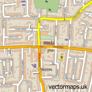
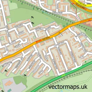
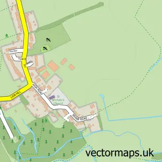
This South Benfleet street map is a detailed vector street map covering a 750m x 750m area. Select a larger area to create and download your own vector street map of South Benfleet.
The 750-metre map sample for South Benfleet covers 427 mapped buildings and approximately 12.3 km of road detail, of which 25 named roads are named. The immediate area includes 1 school, 7 GP surgeries within 2 miles and 7 MOT stations within 2 miles. The wider area around South Benfleet features 3 tourism points of interest and 2 food and drink venues. To create a larger or custom map of South Benfleet, the map builder lets you define your own coverage area and download editable SVG, PDF and PNG files.
Create a larger editable map of South Benfleet
Choose any area you need and generate a high-quality vector map instantly. Perfect for print, planning, design, business and personal use.

This South Benfleet street map in Essex is available as downloadable SVG, PDF and PNG map files, or as a printed map for planning, business, display, education, local information and design work. You can also create a larger custom map area using the map selector.
What this South Benfleet map sample shows
South Benfleet lies within Essex County parish, part of St Mary's ward in the Castle Point District (B) local authority area. The postcode geography for this area includes the SS postcode area, the SS7 postcode district and the SS7 5 postcode sector. Residents fall under the Nhs Mid And South Essex Integrated Care Board for NHS services.
Local features near South Benfleet
Within 2 milesAmenities and services in and around South Benfleet.
Administrative and postcode information for South Benfleet
The local authority covering South Benfleet is Castle Point District (B), within the county of Essex. The settlement lies within St Mary's ward and Essex County civil parish. The SS7 postcode district and SS7 5 postcode sector serve the immediate area. NHS provision in the area is delivered through Mid And South Essex Nhs Foundation Trust.
Nearby street map samples around South Benfleet

More street maps in Essex
750 metre map area coverage
Boundary, postcode and point of interest information for the 750m x 750m rectangle centred on this sample map.
Boundaries containing map centre
Constituency: Castle Point Boro Const
County: Essex County
District: Castle Point District (B)
Icb: NHS Essex ICB
Police Force: essex
Postcode District: SS7
Postcode Sector: SS7 5
Ward: St. Mary's Ward
Nearby boundaries intersecting sample
Ward: Appleton Ward
Postcode coverage
POI category counts
Convenience Store: 4
Indian Restaurant: 4
Banks: 3
Gas Station: 3
Bakery: 2
Barber: 2
Beauty And Spa: 2
Beverage Store: 2
Building Supply Store: 2
Clothing Store: 2
Sample points of interest
- Castle Point Accountancy Ltd
- Digital Dacia
- Sporting Events Ltd
- The Cooperative Food Benfleet
- Auto Trim N Chips
- Furore Products
- GREGGS
- The Bakers Oven
- Barclays Bank
- TSB Bank
- Woolwich
- Albert jack
Create a larger editable map of South Benfleet
This sample shows only a 750 metre area. To create a larger map of South Benfleet, use our map builder to choose your own coverage area, add titles and download editable SVG, PDF and PNG files.
Create a custom map of South Benfleet