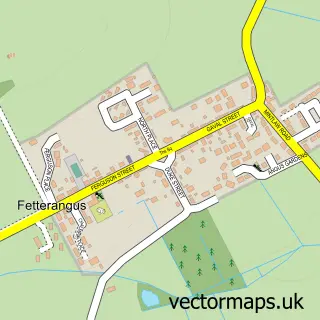
This Stuartfield street map is a detailed vector street map covering a 750m x 750m area. Select a larger area to create and download your own vector street map of Stuartfield.
The 750-metre map sample for Stuartfield covers 326 mapped buildings and approximately 13.3 km of road detail, of which 16 named roads are named. The immediate area includes 1 GP surgery within 2 miles, 1 pub and 1 MOT station, with 2 within 2 miles. The wider area around Stuartfield features 2 tourism points of interest, 1 food and drink venue and 1 campsite within 2 miles. To create a larger or custom map of Stuartfield, the map builder lets you define your own coverage area and download editable SVG, PDF and PNG files.
Create a larger editable map of Stuartfield
Choose any area you need and generate a high-quality vector map instantly. Perfect for print, planning, design, business and personal use.

This Stuartfield street map in Aberdeenshire is available as downloadable SVG, PDF and PNG map files, or as a printed map for planning, business, display, education, local information and design work. You can also create a larger custom map area using the map selector.
What this Stuartfield map sample shows
Stuartfield lies within Aberdeenshire parish, part of Central Buchan ward in the Aberdeenshire local authority area. The postcode geography for this area includes the AB postcode area, the AB42 postcode district and the AB42 5 postcode sector. Residents fall under the Grampian for NHS services.
Local features near Stuartfield
Within 2 milesAmenities and services in and around Stuartfield.
Administrative and postcode information for Stuartfield
The local authority covering Stuartfield is Aberdeenshire, within the county of Aberdeenshire. The settlement lies within Central Buchan ward and Aberdeenshire civil parish. The AB42 postcode district and AB42 5 postcode sector serve the immediate area. NHS provision in the area is delivered through Grampian.
Nearby street map samples around Stuartfield


More street maps in Aberdeenshire
750 metre map area coverage
Boundary, postcode and point of interest information for the 750m x 750m rectangle centred on this sample map.
Boundaries containing map centre
Constituency: Gordon and Buchan Co Const
District: Aberdeenshire
Icb: Grampian
Postcode District: AB42
Postcode Sector: AB42 5
Ward: Central Buchan Ward
Nearby boundaries intersecting sample
No additional intersecting boundaries found.
Postcode coverage
POI category counts
Convenience Store: 3
Automotive Repair: 2
Agricultural Service: 1
Arts And Crafts: 1
Bar: 1
Beauty Salon: 1
Business Manufacturing And Supply: 1
Butcher Shop: 1
Community Center: 1
Community Services Non Profits: 1
Sample points of interest
- Machinery Services GC
- BarbaraRose Crafts
- M G B Motors
- MGB Motors
- Crichie Inn
- A Cut Above
- WP Hardwood Ltd
- Ewan Morrice
- The Village Hall Stuartfield
- Stuartfield Public Hall
- Morrisons Daily
- Nisa Local
Create a larger editable map of Stuartfield
This sample shows only a 750 metre area. To create a larger map of Stuartfield, use our map builder to choose your own coverage area, add titles and download editable SVG, PDF and PNG files.
Create a custom map of Stuartfield