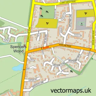
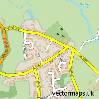
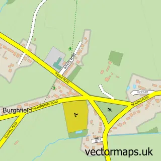
This Three Mile Cross street map is a detailed vector street map covering a 750m x 750m area. Select a larger area to create and download your own vector street map of Three Mile Cross.
The 750-metre map sample for Three Mile Cross covers 385 mapped buildings and approximately 16.2 km of road detail, of which 20 named roads are named. The immediate area includes 1 school, 1 GP surgery within 2 miles, 3 pubs and 1 MOT station, with 12 within 2 miles. The wider area around Three Mile Cross features 1 tourism point of interest and 7 food and drink venues. To create a larger or custom map of Three Mile Cross, the map builder lets you define your own coverage area and download editable SVG, PDF and PNG files.
Create a larger editable map of Three Mile Cross
Choose any area you need and generate a high-quality vector map instantly. Perfect for print, planning, design, business and personal use.

This Three Mile Cross street map in Berkshire is available as downloadable SVG, PDF and PNG map files, or as a printed map for planning, business, display, education, local information and design work. You can also create a larger custom map area using the map selector.
What this Three Mile Cross map sample shows
Three Mile Cross lies within Shinfield Cp parish, part of Shinfield South ward in the Wokingham (B) local authority area. The postcode geography for this area includes the RG postcode area, the RG7 postcode district and the RG7 1 postcode sector. Residents fall under the Nhs Buckinghamshire, Oxfordshire And Berkshire West Integrated Care Board for NHS services.
Local features near Three Mile Cross
Within 2 milesAmenities and services in and around Three Mile Cross.
Administrative and postcode information for Three Mile Cross
The local authority covering Three Mile Cross is Wokingham (B), within the county of Berkshire. The settlement lies within Shinfield South ward and Shinfield Cp civil parish. The RG7 postcode district and RG7 1 postcode sector serve the immediate area. NHS provision in the area is delivered through Royal Berkshire Nhs Foundation Trust.
Nearby street map samples around Three Mile Cross

More street maps in Berkshire
750 metre map area coverage
Boundary, postcode and point of interest information for the 750m x 750m rectangle centred on this sample map.
Boundaries containing map centre
Constituency: Earley and Woodley Boro Const
District: Wokingham (B)
Icb: NHS Thames Valley ICB
Parish: Shinfield CP
Police Force: thames valley
Postcode District: RG7
Postcode Sector: RG7 1
Ward: Spencers Wood & Swallowfield Ward
Nearby boundaries intersecting sample
District: Reading (B)
Postcode District: RG2
Postcode Sector: RG2 8
Ward: Shinfield Ward, Whitley Ward
Postcode coverage
POI category counts
Coffee Shop: 4
Gas Station: 3
Post Office: 3
Pub: 3
Package Locker: 2
Alternative Medicine: 1
Art Gallery: 1
Atms: 1
Automotive Repair: 1
Bicycle Shop: 1
Sample points of interest
- Be Good to Yourselves
- Donna's Delicious Designs
- Fraser Group - Three Mile Cross Service Station (Protected), Three Mile Cross
- Montelle Motors Ltd
- Pete's Bike Shed
- Pete's Bike Shed
- Three Mile Cross Church
- Amore Espresso
- Amore Espresso
- Costa Express
- Wild Bean Cafe
- Camberford Developments
Create a larger editable map of Three Mile Cross
This sample shows only a 750 metre area. To create a larger map of Three Mile Cross, use our map builder to choose your own coverage area, add titles and download editable SVG, PDF and PNG files.
Create a custom map of Three Mile Cross