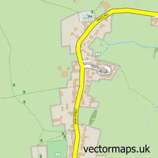
This Tintinhull street map is a detailed vector street map covering a 750m x 750m area. Select a larger area to create and download your own vector street map of Tintinhull.
The 750-metre map sample for Tintinhull covers 176 mapped buildings and approximately 14.3 km of road detail, of which 11 named roads are named. The immediate area includes 1 school and 2 MOT stations within 2 miles. To create a larger or custom map of Tintinhull, the map builder lets you define your own coverage area and download editable SVG, PDF and PNG files.
Create a larger editable map of Tintinhull
Choose any area you need and generate a high-quality vector map instantly. Perfect for print, planning, design, business and personal use.

This Tintinhull street map in Somerset is available as downloadable SVG, PDF and PNG map files, or as a printed map for planning, business, display, education, local information and design work. You can also create a larger custom map area using the map selector.
What this Tintinhull map sample shows
Tintinhull lies within Tintinhull Cp parish, part of Northstone, Ivelchester & St Michael's ward in the Somerset local authority area. The postcode geography for this area includes the BA postcode area, the BA22 postcode district and the BA22 8 postcode sector. Residents fall under the Nhs Somerset Integrated Care Board for NHS services.
Local features near Tintinhull
Within 2 milesAmenities and services in and around Tintinhull.
Administrative and postcode information for Tintinhull
The local authority covering Tintinhull is Somerset, within the county of Somerset. The settlement lies within Northstone, Ivelchester & St Michael's ward and Tintinhull Cp civil parish. The BA22 postcode district and BA22 8 postcode sector serve the immediate area. NHS provision in the area is delivered through Yeovil District Hospital Nhs Foundation Trust.
Nearby street map samples around Tintinhull


More street maps in Somerset
750 metre map area coverage
Boundary, postcode and point of interest information for the 750m x 750m rectangle centred on this sample map.
Boundaries containing map centre
Constituency: Glastonbury and Somerton Co Const
District: Somerset
Icb: NHS Somerset ICB
Parish: Tintinhull CP
Police Force: avon and somerset
Postcode District: BA22
Postcode Sector: BA22 8
Nearby boundaries intersecting sample
Parish: Montacute CP
Postcode District: TA15
Postcode Sector: TA15 6
Postcode coverage
POI category counts
Community Center: 2
Elementary School: 2
Assisted Living Facility: 1
Bar: 1
Church Cathedral: 1
Corporate Office: 1
Dance Club: 1
Flooring Contractors: 1
Holiday Rental Home: 1
Lawyer: 1
Sample points of interest
- Yarlington Housing Group
- Lamb Inn
- St Margaret's Church
- Tintinhull Cafe
- Tintinhull Village Hall Coffee Shop
- Rich Productions Ltd.
- Applejaxlinedancers-Tintinhull Village Hall
- Post Office-Tintinhull
- St. Margaret's CEVA Primary School Tintinhull
- Wychwood
- The Dairy at High House
- Routh Clarke Solicitors
Create a larger editable map of Tintinhull
This sample shows only a 750 metre area. To create a larger map of Tintinhull, use our map builder to choose your own coverage area, add titles and download editable SVG, PDF and PNG files.
Create a custom map of Tintinhull