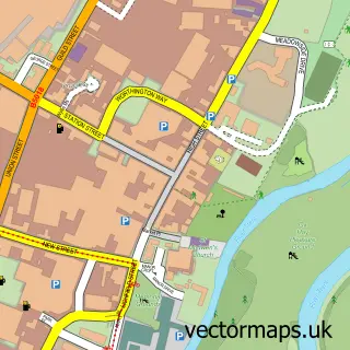
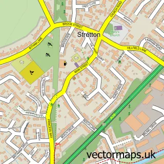
This Tutbury street map is a detailed vector street map covering a 750m x 750m area. Select a larger area to create and download your own vector street map of Tutbury.
The 750-metre map sample for Tutbury covers 347 mapped buildings and approximately 24.4 km of road detail, of which 28 named roads are named. The immediate area includes 1 school, 2 GP surgeries, 8 pubs and 4 MOT stations within 2 miles. The wider area around Tutbury features 1 tourism point of interest, 15 food and drink venues and 1 hotel. To create a larger or custom map of Tutbury, the map builder lets you define your own coverage area and download editable SVG, PDF and PNG files.
Create a larger editable map of Tutbury
Choose any area you need and generate a high-quality vector map instantly. Perfect for print, planning, design, business and personal use.

This Tutbury street map in Staffordshire is available as downloadable SVG, PDF and PNG map files, or as a printed map for planning, business, display, education, local information and design work. You can also create a larger custom map area using the map selector.
What this Tutbury map sample shows
Tutbury lies within Tutbury Cp parish, part of Tutbury And Outwoods ward in the East Staffordshire District (B) local authority area. The postcode geography for this area includes the DE postcode area, the DE13 postcode district and the DE13 9 postcode sector. Residents fall under the Nhs Staffordshire And Stoke-On-Trent Integrated Care Board for NHS services.
Local features near Tutbury
Within 2 milesAmenities and services in and around Tutbury.
Administrative and postcode information for Tutbury
The local authority covering Tutbury is East Staffordshire District (B), within the county of Staffordshire. The settlement lies within Tutbury And Outwoods ward and Tutbury Cp civil parish. The DE13 postcode district and DE13 9 postcode sector serve the immediate area. NHS provision in the area is delivered through University Hospitals Of Derby And Burton Nhs Foundation Trust.
Nearby street map samples around Tutbury

More street maps in Staffordshire
750 metre map area coverage
Boundary, postcode and point of interest information for the 750m x 750m rectangle centred on this sample map.
Boundaries containing map centre
Constituency: Burton and Uttoxeter Co Const
County: Staffordshire County
District: East Staffordshire District (B)
Icb: NHS Staffordshire and Stoke-on-Trent ICB
Parish: Tutbury CP
Police Force: staffordshire
Postcode District: DE13
Postcode Sector: DE13 9
Ward: Dove Ward
Nearby boundaries intersecting sample
No additional intersecting boundaries found.
Postcode coverage
POI category counts
Beauty Salon: 10
Pub: 8
Barber: 5
Restaurant: 4
Beauty And Spa: 3
Cafe: 3
Flowers And Gifts Shop: 3
Hair Salon: 3
Tattoo And Piercing: 3
Antique Store: 2
Sample points of interest
- Ad Como
- Brewery House Antiques
- The Old Chapel Antiques and Collectables Centre
- Orchard House Patisserie
- The Reids Cake Boutique
- Lloyds Bank
- Glastutbury
- Bespoke Barbers Of Tutbury
- Brassos barbers
- Castle Cuts
- Glyns Barbers Tutbury
- I-Cut
Create a larger editable map of Tutbury
This sample shows only a 750 metre area. To create a larger map of Tutbury, use our map builder to choose your own coverage area, add titles and download editable SVG, PDF and PNG files.
Create a custom map of Tutbury