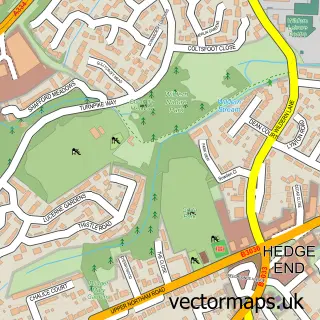
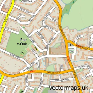
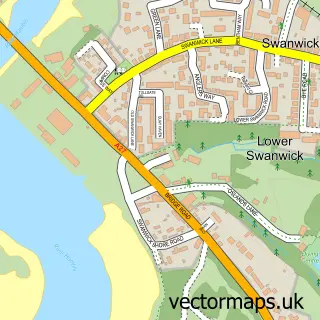
This West End street map is a detailed vector street map covering a 750m x 750m area. Select a larger area to create and download your own vector street map of West End.
The 750-metre map sample for West End covers 521 mapped buildings and approximately 18.7 km of road detail, of which 42 named roads are named. The immediate area includes 2 GP surgeries within 2 miles, 1 pub and 2 MOT stations, with 21 within 2 miles. The wider area around West End features 1 tourism point of interest and 2 food and drink venues. To create a larger or custom map of West End, the map builder lets you define your own coverage area and download editable SVG, PDF and PNG files.
Create a larger editable map of West End
Choose any area you need and generate a high-quality vector map instantly. Perfect for print, planning, design, business and personal use.

This West End street map in Hampshire is available as downloadable SVG, PDF and PNG map files, or as a printed map for planning, business, display, education, local information and design work. You can also create a larger custom map area using the map selector.
What this West End map sample shows
West End lies within West End Cp parish, part of West End North ward in the Eastleigh District (B) local authority area. The postcode geography for this area includes the SO postcode area, the SO30 postcode district and the SO30 3 postcode sector. Residents fall under the Nhs Hampshire And Isle Of Wight Integrated Care Board for NHS services.
Local features near West End
Within 2 milesAmenities and services in and around West End.
Administrative and postcode information for West End
West End lies within West End Cp parish, part of West End North ward in the Eastleigh District (B) local authority area. The postcode geography for this area includes the SO postcode area, the SO30 postcode district and the SO30 3 postcode sector. Residents fall under the Nhs Hampshire And Isle Of Wight Integrated Care Board for NHS services.
Nearby street map samples around West End

More street maps in Hampshire
750 metre map area coverage
Boundary, postcode and point of interest information for the 750m x 750m rectangle centred on this sample map.
Boundaries containing map centre
Constituency: Eastleigh Boro Const
County: Hampshire County
District: Eastleigh District (B)
Icb: NHS Hampshire and Isle of Wight ICB
Parish: West End CP
Police Force: hampshire
Postcode District: SO30
Postcode Sector: SO30 3
Ward: West End South Ward
Nearby boundaries intersecting sample
Constituency: Southampton Itchen Boro Const
District: City of Southampton (B)
Postcode District: SO18
Postcode Sector: SO18 3, SO18 5
Ward: Harefield Ward, West End North Ward
Postcode coverage
POI category counts
Professional Services: 5
Hair Salon: 4
Beauty Salon: 3
Framing Store: 3
Real Estate Agent: 3
Shopping: 3
Automotive: 2
Barber: 2
Community Center: 2
Convenience Store: 2
Sample points of interest
- BBK Accounts Limited
- West End Acupuncture
- Really Excellent Advertising
- St James' Church
- The Rainbow Charity Shop
- Anchor - Glenside
- The Southern Co-Operative West End Southampton, West End
- Prestige Cars by Peter Cooper West End
- Viking Kia
- Motability Scheme at Viking Garages Kia Southampton
- Peter Cooper Modifications (PCM) by Peter Cooper Racing (PCR) Southampton
- Beales Gents Hairdressers
Create a larger editable map of West End
This sample shows only a 750 metre area. To create a larger map of West End, use our map builder to choose your own coverage area, add titles and download editable SVG, PDF and PNG files.
Create a custom map of West End