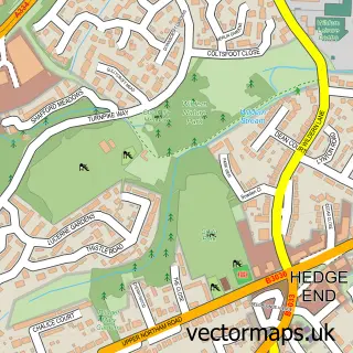
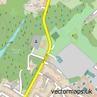
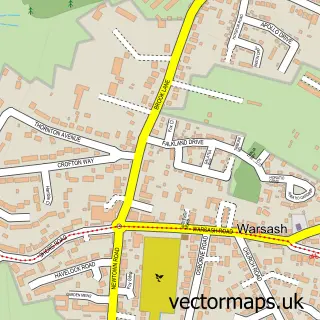
This Bursledon street map is a detailed vector street map covering a 750m x 750m area. Select a larger area to create and download your own vector street map of Bursledon.
The 750-metre map sample for Bursledon covers 166 mapped buildings and approximately 8.9 km of road detail, of which 8 named roads are named. The immediate area includes 4 GP surgeries within 2 miles, 1 pub and 13 MOT stations within 2 miles. The wider area around Bursledon features 1 tourism point of interest, 1 food and drink venue and 2 campsites within 2 miles. To create a larger or custom map of Bursledon, the map builder lets you define your own coverage area and download editable SVG, PDF and PNG files.
Create a larger editable map of Bursledon
Choose any area you need and generate a high-quality vector map instantly. Perfect for print, planning, design, business and personal use.

This Bursledon street map in Hampshire is available as downloadable SVG, PDF and PNG map files, or as a printed map for planning, business, display, education, local information and design work. You can also create a larger custom map area using the map selector.
What this Bursledon map sample shows
Bursledon lies within Bursledon Cp parish, part of Bursledon & Hound North ward in the Eastleigh District (B) local authority area. The postcode geography for this area includes the SO postcode area, the SO31 postcode district and the SO31 8 postcode sector. Residents fall under the Nhs Hampshire And Isle Of Wight Integrated Care Board for NHS services.
Local features near Bursledon
Within 2 milesAmenities and services in and around Bursledon.
Administrative and postcode information for Bursledon
The local authority covering Bursledon is Eastleigh District (B), within the county of Hampshire. The settlement lies within Bursledon & Hound North ward and Bursledon Cp civil parish. The SO31 postcode district and SO31 8 postcode sector serve the immediate area. NHS provision in the area is delivered through University Hospital Southampton Nhs Foundation Trust.
Nearby street map samples around Bursledon

More street maps in Hampshire
750 metre map area coverage
Boundary, postcode and point of interest information for the 750m x 750m rectangle centred on this sample map.
Boundaries containing map centre
Constituency: Hamble Valley Co Const
County: Hampshire County
District: Eastleigh District (B)
Icb: NHS Hampshire and Isle of Wight ICB
Parish: Bursledon CP
Police Force: hampshire
Postcode District: SO31
Postcode Sector: SO31 8
Ward: Bursledon & Hound North Ward
Nearby boundaries intersecting sample
No additional intersecting boundaries found.
Postcode coverage
POI category counts
Boat Service And Repair: 1
Charity Organization: 1
Cottage: 1
Home Service: 1
International Business And Trade Services: 1
Landmark And Historical Building: 1
Pub: 1
Train Station: 1
Sample points of interest
- Elephant Boatyard Ltd
- GAF Centre - Greyladyes Arts Foundation
- Old Bursledon River Cottage
- Pro-Jet Driveway & Patio Cleaning
- R & N Carpenters & Joiners Ltd.
- River Hamble Viewpoint
- The Vine Inn
- Bursledon
Create a larger editable map of Bursledon
This sample shows only a 750 metre area. To create a larger map of Bursledon, use our map builder to choose your own coverage area, add titles and download editable SVG, PDF and PNG files.
Create a custom map of Bursledon