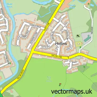
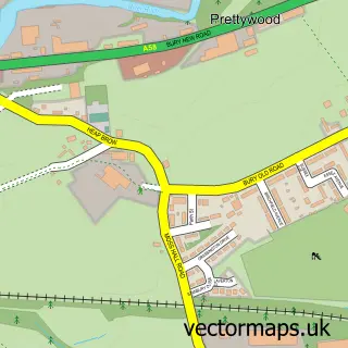
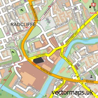
This Whitefield street map is a detailed vector street map covering a 750m x 750m area. Select a larger area to create and download your own vector street map of Whitefield.
The 750-metre map sample for Whitefield covers 463 mapped buildings and approximately 22.9 km of road detail, of which 55 named roads are named. The immediate area includes 1 railway station, 1 GP surgery, with 11 within 2 miles, 2 pubs and 21 MOT stations within 2 miles. The wider area around Whitefield features 2 tourism points of interest and 5 food and drink venues. To create a larger or custom map of Whitefield, the map builder lets you define your own coverage area and download editable SVG, PDF and PNG files.
Create a larger editable map of Whitefield
Choose any area you need and generate a high-quality vector map instantly. Perfect for print, planning, design, business and personal use.

This Whitefield street map in Greater Manchester is available as downloadable SVG, PDF and PNG map files, or as a printed map for planning, business, display, education, local information and design work. You can also create a larger custom map area using the map selector.
What this Whitefield map sample shows
Whitefield lies within Bury District (B) parish, part of Besses ward in the Bury District (B) local authority area. The postcode geography for this area includes the M postcode area, the M45 postcode district and the M45 6 postcode sector. Residents fall under the Nhs Greater Manchester Integrated Care Board for NHS services.
Local features near Whitefield
Within 2 milesAmenities and services in and around Whitefield.
Administrative and postcode information for Whitefield
Whitefield lies within Bury District (B) parish, part of Besses ward in the Bury District (B) local authority area. The postcode geography for this area includes the M postcode area, the M45 postcode district and the M45 6 postcode sector. Residents fall under the Nhs Greater Manchester Integrated Care Board for NHS services.
Nearby street map samples around Whitefield


More street maps in Greater Manchester
750 metre map area coverage
Boundary, postcode and point of interest information for the 750m x 750m rectangle centred on this sample map.
Boundaries containing map centre
Constituency: Bury South Boro Const
District: Bury District (B)
Icb: NHS Greater Manchester ICB
Police Force: greater manchester
Postcode District: M45
Postcode Sector: M45 7
Ward: Unsworth Ward
Nearby boundaries intersecting sample
Postcode Sector: M45 6, M45 8
Ward: Besses Ward, Pilkington Park Ward
Postcode coverage
POI category counts
Beauty Salon: 10
Package Locker: 5
Pizza Restaurant: 5
Barber: 4
Gym: 4
Professional Services: 4
Accountant: 3
Car Dealer: 3
Chinese Restaurant: 3
Contractor: 3
Sample points of interest
- CB Partnership Accountants Whitefield
- John Spibey Associates
- Rose and Co Accountants
- First Aid Safety Training
- Visual Loves Web Design & Digital Marketing
- All Saints, Stand
- Ashleigh Jade Beauty
- Aromathai Spa
- Irwell Valley Housing Association
- Connectelec Ltd.
- Currans Tile & Stone Emporium
- M a Auto Electrics
Create a larger editable map of Whitefield
This sample shows only a 750 metre area. To create a larger map of Whitefield, use our map builder to choose your own coverage area, add titles and download editable SVG, PDF and PNG files.
Create a custom map of Whitefield