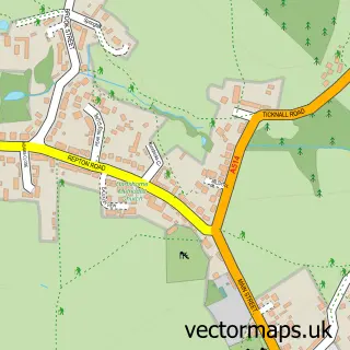
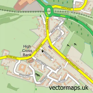
This Woodville street map is a detailed vector street map covering a 750m x 750m area. Select a larger area to create and download your own vector street map of Woodville.
The 750-metre map sample for Woodville covers 475 mapped buildings and approximately 21.2 km of road detail, of which 38 named roads are named. The immediate area includes 2 schools, 4 GP surgeries within 2 miles, 3 pubs and 1 MOT station, with 11 within 2 miles. The wider area around Woodville features 7 food and drink venues. To create a larger or custom map of Woodville, the map builder lets you define your own coverage area and download editable SVG, PDF and PNG files.
Create a larger editable map of Woodville
Choose any area you need and generate a high-quality vector map instantly. Perfect for print, planning, design, business and personal use.

This Woodville street map in Derbyshire is available as downloadable SVG, PDF and PNG map files, or as a printed map for planning, business, display, education, local information and design work. You can also create a larger custom map area using the map selector.
What this Woodville map sample shows
Woodville lies within Woodville Cp parish, part of Woodville ward in the South Derbyshire District local authority area. The postcode geography for this area includes the DE postcode area, the DE11 postcode district and the DE11 7 postcode sector. Residents fall under the Nhs Derby And Derbyshire Integrated Care Board for NHS services.
Local features near Woodville
Within 2 milesAmenities and services in and around Woodville.
Administrative and postcode information for Woodville
Woodville lies within Woodville Cp parish, part of Woodville ward in the South Derbyshire District local authority area. The postcode geography for this area includes the DE postcode area, the DE11 postcode district and the DE11 7 postcode sector. Residents fall under the Nhs Derby And Derbyshire Integrated Care Board for NHS services.
Nearby street map samples around Woodville

More street maps in Derbyshire
750 metre map area coverage
Boundary, postcode and point of interest information for the 750m x 750m rectangle centred on this sample map.
Boundaries containing map centre
Constituency: South Derbyshire Co Const
County: Derbyshire County
District: South Derbyshire District
Icb: NHS Derby and Derbyshire ICB
Parish: Woodville CP
Police Force: derbyshire
Postcode District: DE11
Postcode Sector: DE11 7
Ward: Woodville Ward
Nearby boundaries intersecting sample
Constituency: North West Leicestershire Co Const
County: Leicestershire County
District: North West Leicestershire District
Icb: NHS Leicester Leicestershire and Rutland ICB
Parish: Ashby de la Zouch CP
Police Force: leicestershire
Postcode Sector: DE11 8
Ward: Blackfordby Ward
Postcode coverage
POI category counts
Automotive Repair: 5
Elementary School: 5
Hair Salon: 5
Beauty And Spa: 4
Beauty Salon: 4
Convenience Store: 4
Professional Services: 4
Building Supply Store: 3
Electrician: 3
Indian Restaurant: 3
Sample points of interest
- Barton Accountancy
- Woodville: St Stephen
- Jaspers News Food & Wine - Woodville (Swap), Woodville
- S W Wheel & Body Repairs
- Inflo Vinyl
- Carson Finance
- Auto Tools Direct
- Crescent Motoring Services
- Kwik Fit
- RPS Automotive
- SJ Motors
- Viking Tyre & Service Centre Ltd
Create a larger editable map of Woodville
This sample shows only a 750 metre area. To create a larger map of Woodville, use our map builder to choose your own coverage area, add titles and download editable SVG, PDF and PNG files.
Create a custom map of Woodville