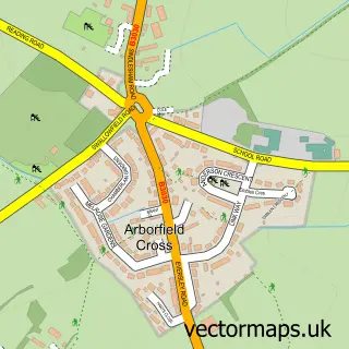
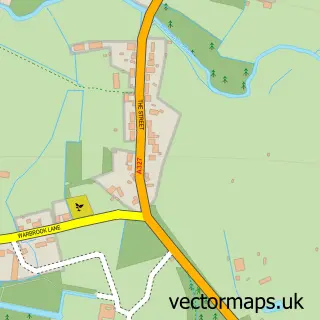
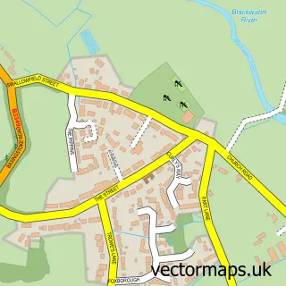
This Arborfield Green street map is a detailed vector street map covering a 750m x 750m area. Select a larger area to create and download your own vector street map of Arborfield Green.
The 750-metre map sample for Arborfield Green covers 329 mapped buildings and approximately 10.0 km of road detail, of which 18 named roads are named. The immediate area includes 1 GP surgery within 2 miles and 5 MOT stations within 2 miles. The wider area around Arborfield Green features 1 tourism point of interest and 2 food and drink venues. To create a larger or custom map of Arborfield Green, the map builder lets you define your own coverage area and download editable SVG, PDF and PNG files.
Create a larger editable map of Arborfield Green
Choose any area you need and generate a high-quality vector map instantly. Perfect for print, planning, design, business and personal use.

This Arborfield Green street map in Berkshire is available as downloadable SVG, PDF and PNG map files, or as a printed map for planning, business, display, education, local information and design work. You can also create a larger custom map area using the map selector.
What this Arborfield Green map sample shows
Arborfield Green lies within Barkham Cp parish, part of Barkham ward in the Wokingham (B) local authority area. The postcode geography for this area includes the RG postcode area, the RG40 postcode district and the RG40 4 postcode sector. Residents fall under the Nhs Buckinghamshire, Oxfordshire And Berkshire West Integrated Care Board for NHS services.
Local features near Arborfield Green
Within 2 milesAmenities and services in and around Arborfield Green.
Administrative and postcode information for Arborfield Green
Arborfield Green lies within Barkham Cp parish, part of Barkham ward in the Wokingham (B) local authority area. The postcode geography for this area includes the RG postcode area, the RG40 postcode district and the RG40 4 postcode sector. Residents fall under the Nhs Buckinghamshire, Oxfordshire And Berkshire West Integrated Care Board for NHS services.
Nearby street map samples around Arborfield Green

More street maps in Berkshire
750 metre map area coverage
Boundary, postcode and point of interest information for the 750m x 750m rectangle centred on this sample map.
Boundaries containing map centre
Constituency: Wokingham Co Const
District: Wokingham (B)
Icb: NHS Thames Valley ICB
Parish: Barkham CP
Police Force: thames valley
Postcode District: RG2
Postcode Sector: RG2 9
Ward: Barkham & Arborfield Ward
Nearby boundaries intersecting sample
Parish: Arborfield and Newland CP
Postcode District: RG40
Postcode Sector: RG40 4
Postcode coverage
POI category counts
Church Cathedral: 2
School: 2
Weight Loss Center: 2
Anglican Church: 1
Cafe: 1
Coffee Shop: 1
Community Center: 1
Construction Services: 1
History Museum: 1
Home Cleaning: 1
Sample points of interest
- PFC St Eligius, Arborfield Green
- Bluebell Box
- Church at The Green
- St Eligius Church
- Stables
- Arborfield Green Community Centre
- Bogdan’s home solutions
- REME Museum
- M & R Cleaning Services
- Crest Nicholson - Nightingale Fields at Arborfield Green
- Hazebrouck Day Nursery
- TheSustainableBagCo
Create a larger editable map of Arborfield Green
This sample shows only a 750 metre area. To create a larger map of Arborfield Green, use our map builder to choose your own coverage area, add titles and download editable SVG, PDF and PNG files.
Create a custom map of Arborfield Green