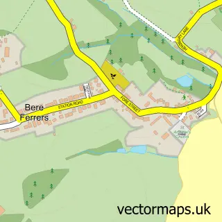
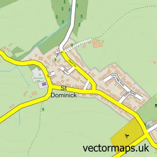
This Bere Alston street map is a detailed vector street map covering a 750m x 750m area. Select a larger area to create and download your own vector street map of Bere Alston.
The 750-metre map sample for Bere Alston covers 446 mapped buildings and approximately 14.4 km of road detail, of which 24 named roads are named. The immediate area includes 2 MOT stations within 2 miles. The wider area around Bere Alston features 2 food and drink venues and 3 hotels. To create a larger or custom map of Bere Alston, the map builder lets you define your own coverage area and download editable SVG, PDF and PNG files.
Create a larger editable map of Bere Alston
Choose any area you need and generate a high-quality vector map instantly. Perfect for print, planning, design, business and personal use.

This Bere Alston street map in Devon is available as downloadable SVG, PDF and PNG map files, or as a printed map for planning, business, display, education, local information and design work. You can also create a larger custom map area using the map selector.
What this Bere Alston map sample shows
Bere Alston lies within Bere Ferrers Cp parish, part of Bere Ferrers ward in the West Devon District (B) local authority area. The postcode geography for this area includes the PL postcode area, the PL20 postcode district and the PL20 7 postcode sector. Residents fall under the Nhs Devon Integrated Care Board for NHS services.
Local features near Bere Alston
Within 2 milesAmenities and services in and around Bere Alston.
Administrative and postcode information for Bere Alston
Bere Alston lies within Bere Ferrers Cp parish, part of Bere Ferrers ward in the West Devon District (B) local authority area. The postcode geography for this area includes the PL postcode area, the PL20 postcode district and the PL20 7 postcode sector. Residents fall under the Nhs Devon Integrated Care Board for NHS services.
Nearby street map samples around Bere Alston

More street maps in Devon
750 metre map area coverage
Boundary, postcode and point of interest information for the 750m x 750m rectangle centred on this sample map.
Boundaries containing map centre
Constituency: Torridge and Tavistock Co Const
County: Devon County
District: West Devon District (B)
Icb: NHS Devon ICB
Parish: Bere Ferrers CP
Police Force: devon and cornwall
Postcode District: PL20
Postcode Sector: PL20 7
Ward: Bere Ferrers Ward
Nearby boundaries intersecting sample
No additional intersecting boundaries found.
Postcode coverage
POI category counts
Doctor: 3
Hotel: 3
Contractor: 2
Convenience Store: 2
Anglican Church: 1
Architectural Designer: 1
Arts And Entertainment: 1
Atms: 1
Banks: 1
Beauty Salon: 1
Sample points of interest
- Holy Trinity
- Elford Maddock Architectural Practice
- South West Chamber Choir
- The Cooperative Food (BF) Bere Alston, Bere Alston
- Lloyds TSB Bank
- Angies nails
- The Victoria Bookshop
- Bere Brewery
- DMD Electrical
- J & S Downing
- Bere Alston United Church
- Hope Cottage
Create a larger editable map of Bere Alston
This sample shows only a 750 metre area. To create a larger map of Bere Alston, use our map builder to choose your own coverage area, add titles and download editable SVG, PDF and PNG files.
Create a custom map of Bere Alston