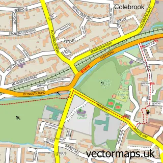
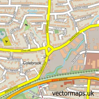
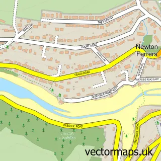
This Elburton Village street map is a detailed vector street map covering a 750m x 750m area. Select a larger area to create and download your own vector street map of Elburton Village.
The 750-metre map sample for Elburton Village covers 634 mapped buildings and approximately 20.4 km of road detail, of which 44 named roads are named. The immediate area includes 1 school, 2 GP surgeries within 2 miles, 2 pubs and 1 MOT station, with 13 within 2 miles. The wider area around Elburton Village features 3 food and drink venues and 1 campsite within 2 miles. To create a larger or custom map of Elburton Village, the map builder lets you define your own coverage area and download editable SVG, PDF and PNG files.
Create a larger editable map of Elburton Village
Choose any area you need and generate a high-quality vector map instantly. Perfect for print, planning, design, business and personal use.

This Elburton Village street map in Devon is available as downloadable SVG, PDF and PNG map files, or as a printed map for planning, business, display, education, local information and design work. You can also create a larger custom map area using the map selector.
What this Elburton Village map sample shows
Elburton Village lies within City Of Plymouth (B) parish, part of Plymstock Dunstone ward in the City Of Plymouth (B) local authority area. The postcode geography for this area includes the PL postcode area, the PL9 postcode district and the PL9 8 postcode sector. Residents fall under the Nhs Devon Integrated Care Board for NHS services.
Local features near Elburton Village
Within 2 milesAmenities and services in and around Elburton Village.
Administrative and postcode information for Elburton Village
Elburton Village lies within City Of Plymouth (B) parish, part of Plymstock Dunstone ward in the City Of Plymouth (B) local authority area. The postcode geography for this area includes the PL postcode area, the PL9 postcode district and the PL9 8 postcode sector. Residents fall under the Nhs Devon Integrated Care Board for NHS services.
Nearby street map samples around Elburton Village

More street maps in Devon
750 metre map area coverage
Boundary, postcode and point of interest information for the 750m x 750m rectangle centred on this sample map.
Boundaries containing map centre
Constituency: South West Devon Co Const
District: City of Plymouth (B)
Icb: NHS Devon ICB
Police Force: devon and cornwall
Postcode District: PL9
Postcode Sector: PL9 8
Ward: Plymstock Dunstone Ward
Nearby boundaries intersecting sample
County: Devon County
District: South Hams District
Parish: Brixton CP
Postcode Sector: PL9 0
Ward: Wembury & Brixton Ward
Postcode coverage
POI category counts
Assisted Living Facility: 2
Automotive Repair: 2
Beauty Salon: 2
Building Supply Store: 2
Carpet Store: 2
Chinese Restaurant: 2
Church Cathedral: 2
Flowers And Gifts Shop: 2
Hair Salon: 2
Interior Design: 2
Sample points of interest
- J Sowden Accountancy Services
- Plymstock Gallery
- Spirit of Skye Piping
- Four Seasons Health Care Plymouth, Wimborne Care Home
- Springfield Nursing Home
- The Cooperative Food (BF) Elburton, Elburton
- CPD Electrics
- DevonDents
- Kenwyn Motor Services
- Warrens Bakery
- Nº36 Wine & Cocktail Bar
- The Barber Shop
Create a larger editable map of Elburton Village
This sample shows only a 750 metre area. To create a larger map of Elburton Village, use our map builder to choose your own coverage area, add titles and download editable SVG, PDF and PNG files.
Create a custom map of Elburton Village