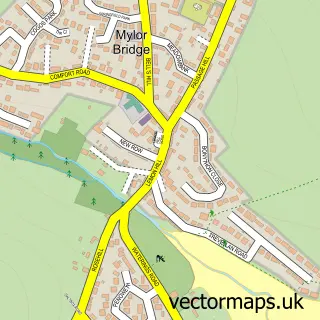
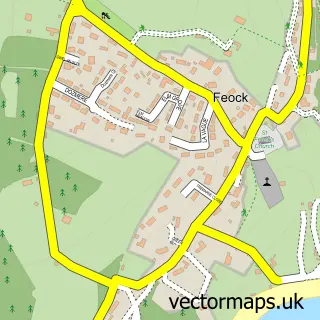
This Flushing street map is a detailed vector street map covering a 750m x 750m area. Select a larger area to create and download your own vector street map of Flushing.
The 750-metre map sample for Flushing covers 187 mapped buildings and approximately 7.0 km of road detail, of which 10 named roads are named. The immediate area includes 1 school, 4 GP surgeries within 2 miles, 4 pubs and 10 MOT stations within 2 miles. The wider area around Flushing features 2 tourism points of interest, 5 food and drink venues and 2 hotels. To create a larger or custom map of Flushing, the map builder lets you define your own coverage area and download editable SVG, PDF and PNG files.
Create a larger editable map of Flushing
Choose any area you need and generate a high-quality vector map instantly. Perfect for print, planning, design, business and personal use.

This Flushing street map in Cornwall is available as downloadable SVG, PDF and PNG map files, or as a printed map for planning, business, display, education, local information and design work. You can also create a larger custom map area using the map selector.
What this Flushing map sample shows
Flushing lies within Mylor Cp parish, part of Penryn East And Mylor ward in the Cornwall local authority area. The postcode geography for this area includes the TR postcode area, the TR11 postcode district and the TR11 5 postcode sector. Residents fall under the Nhs Cornwall And The Isles Of Scilly Integrated Care Board for NHS services.
Local features near Flushing
Within 2 milesAmenities and services in and around Flushing.
Administrative and postcode information for Flushing
Flushing lies within Mylor Cp parish, part of Penryn East And Mylor ward in the Cornwall local authority area. The postcode geography for this area includes the TR postcode area, the TR11 postcode district and the TR11 5 postcode sector. Residents fall under the Nhs Cornwall And The Isles Of Scilly Integrated Care Board for NHS services.
Nearby street map samples around Flushing

More street maps in Cornwall
750 metre map area coverage
Boundary, postcode and point of interest information for the 750m x 750m rectangle centred on this sample map.
Boundaries containing map centre
Constituency: Truro and Falmouth Co Const
District: Cornwall
Icb: NHS Cornwall and the Isles of Scilly ICB
Parish: Mylor CP
Police Force: devon and cornwall
Postcode District: TR11
Postcode Sector: TR11 5
Nearby boundaries intersecting sample
Parish: Falmouth CP
Postcode Sector: TR11 2
Postcode coverage
POI category counts
Travel: 5
Pub: 4
Holiday Rental Home: 3
Transportation: 3
Hotel: 2
Park: 2
Professional Services: 2
Seafood Restaurant: 2
Self Catering Accommodation: 2
Alternative Medicine: 1
Sample points of interest
- Pop Gardens Horticulture Therapy Practitioners
- St Peter
- Ocean Blue
- A Aston
- Falmouth Boat Construction
- The Beauty Room
- Yachting Brokers
- Falmouth Boat Construction
- Sticky Prawn
- Flushing Methodist Church
- A Bray General Builder
- Aston Electricians
Create a larger editable map of Flushing
This sample shows only a 750 metre area. To create a larger map of Flushing, use our map builder to choose your own coverage area, add titles and download editable SVG, PDF and PNG files.
Create a custom map of Flushing