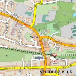
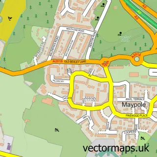
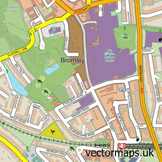
This Grove Park street map is a detailed vector street map covering a 750m x 750m area. Select a larger area to create and download your own vector street map of Grove Park.
The 750-metre map sample for Grove Park covers 357 mapped buildings and approximately 18.0 km of road detail, of which 34 named roads are named. The immediate area includes 1 school, 1 railway station, 17 GP surgeries within 2 miles and 3 pubs among other local services. The wider area around Grove Park features 4 tourism points of interest and 7 food and drink venues. To create a larger or custom map of Grove Park, the map builder lets you define your own coverage area and download editable SVG, PDF and PNG files.
Create a larger editable map of Grove Park
Choose any area you need and generate a high-quality vector map instantly. Perfect for print, planning, design, business and personal use.

This Grove Park street map in Greater London is available as downloadable SVG, PDF and PNG map files, or as a printed map for planning, business, display, education, local information and design work. You can also create a larger custom map area using the map selector.
What this Grove Park map sample shows
Grove Park lies within Greater London Authority parish, part of Grove Park ward in the Lewisham London Boro local authority area. The postcode geography for this area includes the SE postcode area, the SE12 postcode district and the SE12 0 postcode sector. Residents fall under the Nhs South East London Integrated Care Board for NHS services.
Local features near Grove Park
Within 2 milesAmenities and services in and around Grove Park.
Administrative and postcode information for Grove Park
Grove Park lies within Greater London Authority parish, part of Grove Park ward in the Lewisham London Boro local authority area. The postcode geography for this area includes the SE postcode area, the SE12 postcode district and the SE12 0 postcode sector. Residents fall under the Nhs South East London Integrated Care Board for NHS services.
Nearby street map samples around Grove Park


More street maps in Greater London
750 metre map area coverage
Boundary, postcode and point of interest information for the 750m x 750m rectangle centred on this sample map.
Boundaries containing map centre
Constituency: Lewisham East Boro Const
County: Greater London Authority
District: Lewisham London Boro
Icb: NHS South East London ICB
Police Force: metropolitan
Postcode District: SE12
Postcode Sector: SE12 0
Ward: Grove Park Ward
Nearby boundaries intersecting sample
Constituency: Bromley and Biggin Hill Boro Const
District: Bromley London Boro
Postcode District: BR1
Postcode Sector: BR1 5, SE12 9
Ward: Downham Ward, Plaistow Ward
Postcode coverage
POI category counts
Beauty Salon: 4
Church Cathedral: 4
Convenience Store: 4
Armed Forces Branch: 3
Contractor: 3
Dentist: 3
Gas Station: 3
Jewelry Store: 3
Key And Locksmith: 3
Plumbing: 3
Sample points of interest
- The Training Station 1-1 Power Plate Studio
- Penny Men Europe Penny Press Souvenir Machines
- Lee, St Augustine
- RSPCA Charity Shop
- 106th (Yeomanry) Regiment Royal Artillery
- 265 Home Counties Battery Royal Artillery Within 106 Regiment
- Territorial Army
- Juga Homes
- ATM (Post Office)
- Grove Park Station - London & South Eastern Railway, Grove Park
- Ringway Woodland Gardens
- Express Finance
Create a larger editable map of Grove Park
This sample shows only a 750 metre area. To create a larger map of Grove Park, use our map builder to choose your own coverage area, add titles and download editable SVG, PDF and PNG files.
Create a custom map of Grove Park