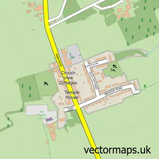
This Hullbridge street map is a detailed vector street map covering a 750m x 750m area. Select a larger area to create and download your own vector street map of Hullbridge.
The 750-metre map sample for Hullbridge covers 708 mapped buildings and approximately 16.6 km of road detail, of which 30 named roads are named. The immediate area includes 1 GP surgery, with 2 within 2 miles and 9 MOT stations within 2 miles. The wider area around Hullbridge features 4 food and drink venues. To create a larger or custom map of Hullbridge, the map builder lets you define your own coverage area and download editable SVG, PDF and PNG files.
Create a larger editable map of Hullbridge
Choose any area you need and generate a high-quality vector map instantly. Perfect for print, planning, design, business and personal use.

This Hullbridge street map in Essex is available as downloadable SVG, PDF and PNG map files, or as a printed map for planning, business, display, education, local information and design work. You can also create a larger custom map area using the map selector.
What this Hullbridge map sample shows
Hullbridge lies within Hullbridge Cp parish, part of Hullbridge ward in the Rochford District local authority area. The postcode geography for this area includes the SS postcode area, the SS5 postcode district and the SS5 6 postcode sector. Residents fall under the Nhs Mid And South Essex Integrated Care Board for NHS services.
Local features near Hullbridge
Within 2 milesAmenities and services in and around Hullbridge.
Administrative and postcode information for Hullbridge
Hullbridge lies within Hullbridge Cp parish, part of Hullbridge ward in the Rochford District local authority area. The postcode geography for this area includes the SS postcode area, the SS5 postcode district and the SS5 6 postcode sector. Residents fall under the Nhs Mid And South Essex Integrated Care Board for NHS services.
Nearby street map samples around Hullbridge


More street maps in Essex
750 metre map area coverage
Boundary, postcode and point of interest information for the 750m x 750m rectangle centred on this sample map.
Boundaries containing map centre
Constituency: Rayleigh and Wickford Co Const
County: Essex County
District: Rochford District
Icb: NHS Essex ICB
Parish: Hullbridge CP
Police Force: essex
Postcode District: SS5
Postcode Sector: SS5 6
Ward: Hullbridge Ward
Nearby boundaries intersecting sample
No additional intersecting boundaries found.
Postcode coverage
POI category counts
Coffee Shop: 3
Contractor: 3
Professional Services: 3
Beauty Salon: 2
Corporate Entertainment Services: 2
Doctor: 2
Medical Center: 2
Pet Groomer: 2
Veterinarian: 2
Anglican Church: 1
Sample points of interest
- St. Thomas, Hullbridge
- Golden Crust Bakery
- Hullbridge Barber
- Miller Street beauty studio
- Hot Gossip Hair & Beauty Salon
- Perfect Beauty by Rosa
- Amanda Every
- Enviro Clear
- Aces Executive Cars
- Gold Lion
- St Thomas of Canterbury Church
- I C E
Create a larger editable map of Hullbridge
This sample shows only a 750 metre area. To create a larger map of Hullbridge, use our map builder to choose your own coverage area, add titles and download editable SVG, PDF and PNG files.
Create a custom map of Hullbridge