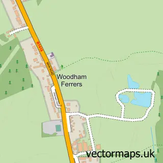
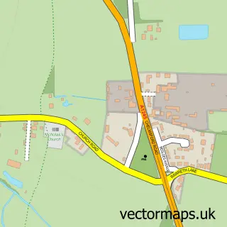
This South Woodham Ferrers street map is a detailed vector street map covering a 750m x 750m area. Select a larger area to create and download your own vector street map of South Woodham Ferrers.
The 750-metre map sample for South Woodham Ferrers covers 551 mapped buildings and approximately 16.8 km of road detail, of which 42 named roads are named. The immediate area includes 4 primary schools and 1 secondary school, 2 GP surgeries within 2 miles, 2 pubs and 1 MOT station, with 6 within 2 miles. The wider area around South Woodham Ferrers features 4 tourism points of interest, 8 food and drink venues and 2 hotels. To create a larger or custom map of South Woodham Ferrers, the map builder lets you define your own coverage area and download editable SVG, PDF and PNG files.
Create a larger editable map of South Woodham Ferrers
Choose any area you need and generate a high-quality vector map instantly. Perfect for print, planning, design, business and personal use.

This South Woodham Ferrers street map in Essex is available as downloadable SVG, PDF and PNG map files, or as a printed map for planning, business, display, education, local information and design work. You can also create a larger custom map area using the map selector.
What this South Woodham Ferrers map sample shows
South Woodham Ferrers lies within South Woodham Ferrers Cp parish, part of South Woodham-Elmwood And Woodville ward in the Chelmsford District (B) local authority area. The postcode geography for this area includes the CM postcode area, the CM3 postcode district and the CM3 5 postcode sector. Residents fall under the Nhs Mid And South Essex Integrated Care Board for NHS services.
Local features near South Woodham Ferrers
Within 2 milesAmenities and services in and around South Woodham Ferrers.
Administrative and postcode information for South Woodham Ferrers
South Woodham Ferrers lies within South Woodham Ferrers Cp parish, part of South Woodham-Elmwood And Woodville ward in the Chelmsford District (B) local authority area. The postcode geography for this area includes the CM postcode area, the CM3 postcode district and the CM3 5 postcode sector. Residents fall under the Nhs Mid And South Essex Integrated Care Board for NHS services.
Nearby street map samples around South Woodham Ferrers


More street maps in Essex
750 metre map area coverage
Boundary, postcode and point of interest information for the 750m x 750m rectangle centred on this sample map.
Boundaries containing map centre
Constituency: Maldon Co Const
County: Essex County
District: Chelmsford District (B)
Icb: NHS Essex ICB
Parish: South Woodham Ferrers CP
Police Force: essex
Postcode District: CM3
Postcode Sector: CM3 5
Ward: South Woodham-Elmwood and Woodville Ward
Nearby boundaries intersecting sample
Ward: South Woodham-Chetwood and Collingwood Ward
Postcode coverage
POI category counts
Beauty Salon: 9
Hair Salon: 9
Tattoo And Piercing: 8
Indian Restaurant: 6
Dentist: 5
Accountant: 4
Alternative Medicine: 4
Chinese Restaurant: 4
Education: 4
Fast Food Restaurant: 4
Sample points of interest
- CEM Bookkeeping & Accounting Ltd.
- Kayli Accounts Ltd
- Khan Thornton
- Shirley Smith & Co Ltd
- Food Allergy Testing
- Leigh & Woodham Clinic
- Milli Valentova Osteopathy
- Osteopath Network Chelmsford
- South Woodham Ferrers: Holy Trinity
- Farleigh Hospice Shop
- Bairstow Eves
- The Sewing Box
Create a larger editable map of South Woodham Ferrers
This sample shows only a 750 metre area. To create a larger map of South Woodham Ferrers, use our map builder to choose your own coverage area, add titles and download editable SVG, PDF and PNG files.
Create a custom map of South Woodham Ferrers