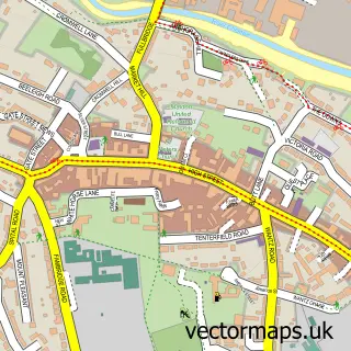
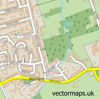
This Latchingdon street map is a detailed vector street map covering a 750m x 750m area. Select a larger area to create and download your own vector street map of Latchingdon.
The 750-metre map sample for Latchingdon covers 319 mapped buildings and approximately 10.2 km of road detail, of which 20 named roads are named. The immediate area includes 1 school, 1 GP surgery within 2 miles, 1 pub and 3 MOT stations within 2 miles. The wider area around Latchingdon features 2 food and drink venues and 1 hotel. To create a larger or custom map of Latchingdon, the map builder lets you define your own coverage area and download editable SVG, PDF and PNG files.
Create a larger editable map of Latchingdon
Choose any area you need and generate a high-quality vector map instantly. Perfect for print, planning, design, business and personal use.

This Latchingdon street map in Essex is available as downloadable SVG, PDF and PNG map files, or as a printed map for planning, business, display, education, local information and design work. You can also create a larger custom map area using the map selector.
What this Latchingdon map sample shows
Latchingdon lies within Latchingdon Cp parish, part of Althorne ward in the Maldon District (B) local authority area. The postcode geography for this area includes the CM postcode area, the CM3 postcode district and the CM3 6 postcode sector. Residents fall under the Nhs Mid And South Essex Integrated Care Board for NHS services.
Local features near Latchingdon
Within 2 milesAmenities and services in and around Latchingdon.
Administrative and postcode information for Latchingdon
Latchingdon lies within Latchingdon Cp parish, part of Althorne ward in the Maldon District (B) local authority area. The postcode geography for this area includes the CM postcode area, the CM3 postcode district and the CM3 6 postcode sector. Residents fall under the Nhs Mid And South Essex Integrated Care Board for NHS services.
Nearby street map samples around Latchingdon


More street maps in Essex
750 metre map area coverage
Boundary, postcode and point of interest information for the 750m x 750m rectangle centred on this sample map.
Boundaries containing map centre
Constituency: Maldon Co Const
County: Essex County
District: Maldon District (B)
Icb: NHS Essex ICB
Parish: Latchingdon CP
Police Force: essex
Postcode District: CM3
Postcode Sector: CM3 6
Ward: Althorne Ward
Nearby boundaries intersecting sample
No additional intersecting boundaries found.
Postcode coverage
POI category counts
Church Cathedral: 2
Driving School: 2
Fence And Gate Sales Service: 2
Pizza Restaurant: 2
Professional Services: 2
Shipping Center: 2
Sports Club And League: 2
Anglican Church: 1
Arts And Crafts: 1
Assisted Living Facility: 1
Sample points of interest
- Latchingdon: Christchurch
- Spytech
- One Support
- Red Lion Inn
- Holly's Diner and Crouch Motel
- Christ Church
- Latchingdon Spiritualists
- Latchingdon Corral - Country & Line Dance
- Carr Grab Hire Limited
- Latchingdon Stores
- Essex Pet Crematorium
- K & W & Daughters Driver Training Services
Create a larger editable map of Latchingdon
This sample shows only a 750 metre area. To create a larger map of Latchingdon, use our map builder to choose your own coverage area, add titles and download editable SVG, PDF and PNG files.
Create a custom map of Latchingdon