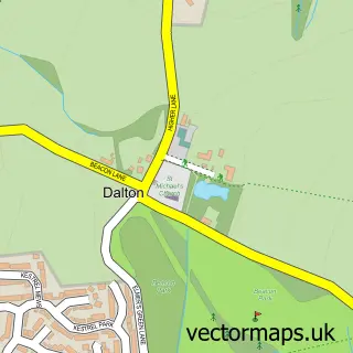
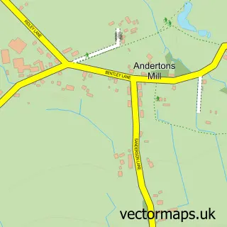
This Newburgh street map is a detailed vector street map covering a 750m x 750m area. Select a larger area to create and download your own vector street map of Newburgh.
The 750-metre map sample for Newburgh covers 244 mapped buildings and approximately 11.0 km of road detail, of which 17 named roads are named. The immediate area includes 1 school, 2 GP surgeries within 2 miles and 1 pub. The wider area around Newburgh features 1 tourism point of interest, 2 food and drink venues and 1 hotel. To create a larger or custom map of Newburgh, the map builder lets you define your own coverage area and download editable SVG, PDF and PNG files.
Create a larger editable map of Newburgh
Choose any area you need and generate a high-quality vector map instantly. Perfect for print, planning, design, business and personal use.

This Newburgh street map in Lancashire is available as downloadable SVG, PDF and PNG map files, or as a printed map for planning, business, display, education, local information and design work. You can also create a larger custom map area using the map selector.
What this Newburgh map sample shows
Newburgh lies within Newburgh Cp parish, part of Newburgh ward in the West Lancashire District (B) local authority area. The postcode geography for this area includes the WN postcode area, the WN8 postcode district and the WN8 7 postcode sector. Residents fall under the Nhs Lancashire And South Cumbria Integrated Care Board for NHS services.
Local features near Newburgh
Within 2 milesAmenities and services in and around Newburgh.
Administrative and postcode information for Newburgh
Newburgh lies within Newburgh Cp parish, part of Newburgh ward in the West Lancashire District (B) local authority area. The postcode geography for this area includes the WN postcode area, the WN8 postcode district and the WN8 7 postcode sector. Residents fall under the Nhs Lancashire And South Cumbria Integrated Care Board for NHS services.
Nearby street map samples around Newburgh

More street maps in Lancashire
750 metre map area coverage
Boundary, postcode and point of interest information for the 750m x 750m rectangle centred on this sample map.
Boundaries containing map centre
Constituency: West Lancashire Co Const
County: Lancashire County
District: West Lancashire District (B)
Icb: NHS Lancashire and South Cumbria ICB
Parish: Newburgh CP
Police Force: lancashire
Postcode District: WN8
Postcode Sector: WN8 7
Ward: Rural North East Ward
Nearby boundaries intersecting sample
Parish: Dalton CP
Postcode coverage
POI category counts
Post Office: 2
Automotive Repair: 1
Charity Organization: 1
Church Cathedral: 1
Coffee Shop: 1
Contractor: 1
Elementary School: 1
Farmers Market: 1
Hotel: 1
Laboratory Testing: 1
Sample points of interest
- A B Autos
- Bella and Brave Animal Sanctuary
- Christ Church Newburgh
- Newburgh Store & Coffee Shop
- Access Builders & Loft Conversions
- Newburgh Church of England Primary School
- Wilton House Farm Shop
- Marston's Estates
- A.B Autos Newburgh
- Newburgh, Lancashire
- Northwest Management Solutions
- GN Bathrooms and Kitchens
Create a larger editable map of Newburgh
This sample shows only a 750 metre area. To create a larger map of Newburgh, use our map builder to choose your own coverage area, add titles and download editable SVG, PDF and PNG files.
Create a custom map of Newburgh