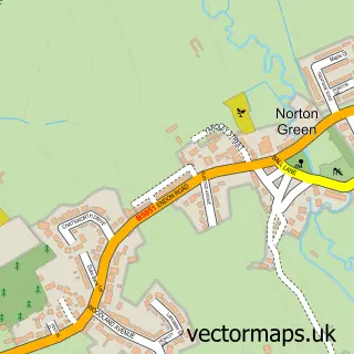
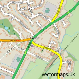
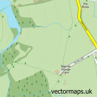
This Norton-Le-Moors street map is a detailed vector street map covering a 750m x 750m area. Select a larger area to create and download your own vector street map of Norton-Le-Moors.
The 750-metre map sample for Norton-Le-Moors covers 438 mapped buildings and approximately 13.3 km of road detail, of which 28 named roads are named. The immediate area includes 1 GP surgery, with 8 within 2 miles, 1 pub and 20 MOT stations within 2 miles. The wider area around Norton-Le-Moors features 3 food and drink venues. To create a larger or custom map of Norton-Le-Moors, the map builder lets you define your own coverage area and download editable SVG, PDF and PNG files.
Create a larger editable map of Norton-Le-Moors
Choose any area you need and generate a high-quality vector map instantly. Perfect for print, planning, design, business and personal use.

This Norton-Le-Moors street map in Staffordshire is available as downloadable SVG, PDF and PNG map files, or as a printed map for planning, business, display, education, local information and design work. You can also create a larger custom map area using the map selector.
What this Norton-Le-Moors map sample shows
Norton-Le-Moors lies within City Of Stoke-On-Trent (B) parish, part of Baddeley, Milton And Norton ward in the City Of Stoke-On-Trent (B) local authority area. The postcode geography for this area includes the ST postcode area, the ST6 postcode district and the ST6 8 postcode sector. Residents fall under the Nhs Staffordshire And Stoke-On-Trent Integrated Care Board for NHS services.
Local features near Norton-Le-Moors
Within 2 milesAmenities and services in and around Norton-Le-Moors.
Administrative and postcode information for Norton-Le-Moors
Norton-Le-Moors lies within City Of Stoke-On-Trent (B) parish, part of Baddeley, Milton And Norton ward in the City Of Stoke-On-Trent (B) local authority area. The postcode geography for this area includes the ST postcode area, the ST6 postcode district and the ST6 8 postcode sector. Residents fall under the Nhs Staffordshire And Stoke-On-Trent Integrated Care Board for NHS services.
Nearby street map samples around Norton-Le-Moors

More street maps in Staffordshire
750 metre map area coverage
Boundary, postcode and point of interest information for the 750m x 750m rectangle centred on this sample map.
Boundaries containing map centre
Constituency: Stoke-on-Trent North Boro Const
District: City of Stoke-on-Trent (B)
Icb: NHS Staffordshire and Stoke-on-Trent ICB
Police Force: staffordshire
Postcode District: ST6
Postcode Sector: ST6 8
Ward: Baddeley, Milton & Norton Ward
Nearby boundaries intersecting sample
No additional intersecting boundaries found.
Postcode coverage
POI category counts
Convenience Store: 5
Beauty Salon: 4
Doctor: 3
Beauty And Spa: 2
Business Management Services: 2
Church Cathedral: 2
Gas Station: 2
Professional Services: 2
Rental Kiosks: 2
Advertising Agency: 1
Sample points of interest
- P D Components
- St Bartholomew’s, Norton-le-Moors
- The Cooperative Food (BF) Norton (ERF), Norton
- Lovatt Hair Studios
- The Cutting Room
- BAMBUs
- Beauty by Definition
- BeautybyLara
- Mirro Image
- Nathan Stevenson Bookkeeping
- Green Guys 4 U
- Graphix
Create a larger editable map of Norton-Le-Moors
This sample shows only a 750 metre area. To create a larger map of Norton-Le-Moors, use our map builder to choose your own coverage area, add titles and download editable SVG, PDF and PNG files.
Create a custom map of Norton-Le-Moors