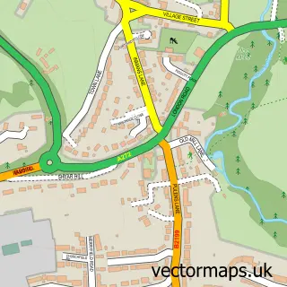
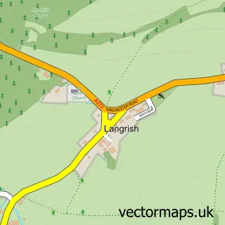
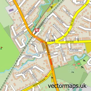
This Petersfield street map is a detailed vector street map covering a 750m x 750m area. Select a larger area to create and download your own vector street map of Petersfield.
The 750-metre map sample for Petersfield covers 324 mapped buildings and approximately 16.1 km of road detail, of which 41 named roads are named. The immediate area includes 1 primary school and 1 secondary school, 2 GP surgeries, 9 pubs and 1 MOT station, with 5 within 2 miles. The wider area around Petersfield features 7 tourism points of interest, 30 food and drink venues and 1 hotel. To create a larger or custom map of Petersfield, the map builder lets you define your own coverage area and download editable SVG, PDF and PNG files.
Create a larger editable map of Petersfield
Choose any area you need and generate a high-quality vector map instantly. Perfect for print, planning, design, business and personal use.

This Petersfield street map in Hampshire is available as downloadable SVG, PDF and PNG map files, or as a printed map for planning, business, display, education, local information and design work. You can also create a larger custom map area using the map selector.
What this Petersfield map sample shows
Petersfield lies within Petersfield Cp parish, part of Petersfield St Peter's ward in the East Hampshire District local authority area. The postcode geography for this area includes the GU postcode area, the GU31 postcode district and the GU31 4 postcode sector. Residents fall under the Nhs Hampshire And Isle Of Wight Integrated Care Board for NHS services.
Local features near Petersfield
Within 2 milesAmenities and services in and around Petersfield.
Administrative and postcode information for Petersfield
The local authority covering Petersfield is East Hampshire District, within the county of Hampshire. The settlement lies within Petersfield St Peter's ward and Petersfield Cp civil parish. The GU31 postcode district and GU31 4 postcode sector serve the immediate area. NHS provision in the area is delivered through Portsmouth Hospitals University National Health Service Trust.
Nearby street map samples around Petersfield

More street maps in Hampshire
750 metre map area coverage
Boundary, postcode and point of interest information for the 750m x 750m rectangle centred on this sample map.
Boundaries containing map centre
Constituency: East Hampshire Co Const
County: Hampshire County
District: East Hampshire District
Icb: NHS Hampshire and Isle of Wight ICB
Parish: Petersfield CP
Police Force: hampshire
Postcode District: GU32
Postcode Sector: GU32 3
Ward: Petersfield St. Peter's Ward
Nearby boundaries intersecting sample
Postcode District: GU31
Postcode Sector: GU31 4
Ward: Petersfield Bell Hill Ward, Petersfield Causeway Ward, Petersfield Heath Ward
Postcode coverage
POI category counts
Clothing Store: 18
Real Estate Agent: 16
Cafe: 13
Professional Services: 13
Beauty Salon: 11
Hair Salon: 9
Pub: 9
Dentist: 8
Barber: 7
Naturopathic Holistic: 7
Sample points of interest
- Firestone Accountants
- Wallis White & Co
- Fast Healthcare
- Agent8 Design
- Cookson Design
- Videsco
- Forest Cars
- Hypnotherapy for Positive Change
- Life Changers
- The Centre - Petersfield Ltd.
- The Centre of Complimentary Medicine
- St Peter's Church Petersfield
Create a larger editable map of Petersfield
This sample shows only a 750 metre area. To create a larger map of Petersfield, use our map builder to choose your own coverage area, add titles and download editable SVG, PDF and PNG files.
Create a custom map of Petersfield