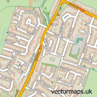
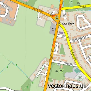
This Rainford street map is a detailed vector street map covering a 750m x 750m area. Select a larger area to create and download your own vector street map of Rainford.
The 750-metre map sample for Rainford covers 431 mapped buildings and approximately 16.8 km of road detail, of which 36 named roads are named. The immediate area includes 1 school, 1 GP surgery, with 2 within 2 miles, 5 pubs and 1 MOT station, with 7 within 2 miles. The wider area around Rainford features 4 tourism points of interest and 9 food and drink venues. To create a larger or custom map of Rainford, the map builder lets you define your own coverage area and download editable SVG, PDF and PNG files.
Create a larger editable map of Rainford
Choose any area you need and generate a high-quality vector map instantly. Perfect for print, planning, design, business and personal use.

This Rainford street map in Merseyside is available as downloadable SVG, PDF and PNG map files, or as a printed map for planning, business, display, education, local information and design work. You can also create a larger custom map area using the map selector.
What this Rainford map sample shows
Rainford lies within Rainford Cp parish, part of Rainford ward in the St. Helens District (B) local authority area. The postcode geography for this area includes the WA postcode area, the WA11 postcode district and the WA11 8 postcode sector. Residents fall under the Nhs Cheshire And Merseyside Integrated Care Board for NHS services.
Local features near Rainford
Within 2 milesAmenities and services in and around Rainford.
Administrative and postcode information for Rainford
The local authority covering Rainford is St. Helens District (B), within the county of Merseyside. The settlement lies within Rainford ward and Rainford Cp civil parish. The WA11 postcode district and WA11 8 postcode sector serve the immediate area. NHS provision in the area is delivered through Mersey And West Lancashire Teaching Hospitals Nhs Trust.
Nearby street map samples around Rainford

More street maps in Merseyside
750 metre map area coverage
Boundary, postcode and point of interest information for the 750m x 750m rectangle centred on this sample map.
Boundaries containing map centre
Constituency: St. Helens North Co Const
District: St. Helens District (B)
Icb: NHS Cheshire and Merseyside ICB
Parish: Rainford CP
Police Force: merseyside
Postcode District: WA11
Postcode Sector: WA11 8
Ward: Rainford Ward
Nearby boundaries intersecting sample
No additional intersecting boundaries found.
Postcode coverage
POI category counts
Beauty Salon: 12
Pub: 5
Elementary School: 4
Electrician: 3
It Service And Computer Repair: 3
Park: 3
Professional Services: 3
Anglican Church: 2
Barber: 2
Butcher Shop: 2
Sample points of interest
- Rainford Hall
- Rainford Rangers jfc
- All Saints, Rainford Parish Church
- Rainford Parish Church
- Summer Strum
- The Cooperative Food (BF) Rainford (ERF), Rainford
- Tabern Electrical
- Mortgage Guarantee
- Waterfields
- The Men's Room Barber Shop
- The Mens Room
- Copper 31
Create a larger editable map of Rainford
This sample shows only a 750 metre area. To create a larger map of Rainford, use our map builder to choose your own coverage area, add titles and download editable SVG, PDF and PNG files.
Create a custom map of Rainford