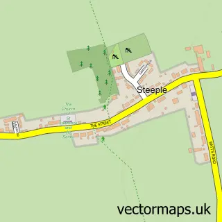
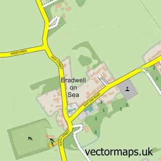
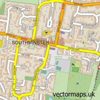
This St Lawrence street map is a detailed vector street map covering a 750m x 750m area. Select a larger area to create and download your own vector street map of St Lawrence.
The 750-metre map sample for St Lawrence covers 417 mapped buildings and approximately 10.3 km of road detail, of which 14 named roads are named. The immediate area includes 2 pubs. The wider area around St Lawrence features 3 food and drink venues. To create a larger or custom map of St Lawrence, the map builder lets you define your own coverage area and download editable SVG, PDF and PNG files.
Create a larger editable map of St Lawrence
Choose any area you need and generate a high-quality vector map instantly. Perfect for print, planning, design, business and personal use.

This St Lawrence street map in Essex is available as downloadable SVG, PDF and PNG map files, or as a printed map for planning, business, display, education, local information and design work. You can also create a larger custom map area using the map selector.
What this St Lawrence map sample shows
St Lawrence lies within St. Lawrence Cp parish, part of Mayland ward in the Maldon District (B) local authority area. The postcode geography for this area includes the CM postcode area, the CM0 postcode district and the CM0 7 postcode sector. Residents fall under the Nhs Mid And South Essex Integrated Care Board for NHS services.
Local features near St Lawrence
Within 2 milesAmenities and services in and around St Lawrence.
Administrative and postcode information for St Lawrence
St Lawrence lies within St. Lawrence Cp parish, part of Mayland ward in the Maldon District (B) local authority area. The postcode geography for this area includes the CM postcode area, the CM0 postcode district and the CM0 7 postcode sector. Residents fall under the Nhs Mid And South Essex Integrated Care Board for NHS services.
Nearby street map samples around St Lawrence

More street maps in Essex
750 metre map area coverage
Boundary, postcode and point of interest information for the 750m x 750m rectangle centred on this sample map.
Boundaries containing map centre
Constituency: Maldon Co Const
County: Essex County
District: Maldon District (B)
Icb: NHS Essex ICB
Parish: St. Lawrence CP
Police Force: essex
Postcode District: CM0
Postcode Sector: CM0 7
Ward: Mayland Ward
Nearby boundaries intersecting sample
No additional intersecting boundaries found.
Postcode coverage
POI category counts
Indian Restaurant: 4
Building Supply Store: 2
Construction Services: 2
Post Office: 2
Pub: 2
Anglican Church: 1
Builders: 1
Business Management Services: 1
Community Services Non Profits: 1
Condominium: 1
Sample points of interest
- St Lawrence Church Centre
- House Extension Builders - Heritage Conversions
- Essex Mix
- Garden-irrigation-lighting-design
- Mr Sweeps Stove Shop
- The Stone Watersports Club
- St Lawrence Holiday Park
- EO Jones & Sons
- Heritage Conversions
- Calmasey Building Services
- Dairy Stores
- Star Struck Theatre School
Create a larger editable map of St Lawrence
This sample shows only a 750 metre area. To create a larger map of St Lawrence, use our map builder to choose your own coverage area, add titles and download editable SVG, PDF and PNG files.
Create a custom map of St Lawrence