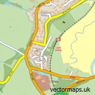
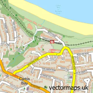
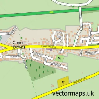
This Uny Lelant street map is a detailed vector street map covering a 750m x 750m area. Select a larger area to create and download your own vector street map of Uny Lelant.
The 750-metre map sample for Uny Lelant covers 284 mapped buildings and approximately 9.5 km of road detail, of which 19 named roads are named. The immediate area includes 1 railway station, 1 GP surgery within 2 miles, 2 pubs and 4 MOT stations within 2 miles. The wider area around Uny Lelant features 1 tourism point of interest, 3 food and drink venues and 5 campsites within 2 miles. To create a larger or custom map of Uny Lelant, the map builder lets you define your own coverage area and download editable SVG, PDF and PNG files.
Create a larger editable map of Uny Lelant
Choose any area you need and generate a high-quality vector map instantly. Perfect for print, planning, design, business and personal use.

This Uny Lelant street map in Cornwall is available as downloadable SVG, PDF and PNG map files, or as a printed map for planning, business, display, education, local information and design work. You can also create a larger custom map area using the map selector.
What this Uny Lelant map sample shows
Uny Lelant lies within St. Ives Cp parish, part of Lelant And Carbis Bay ward in the Cornwall local authority area. The postcode geography for this area includes the TR postcode area, the TR26 postcode district and the TR26 3 postcode sector. Residents fall under the Nhs Cornwall And The Isles Of Scilly Integrated Care Board for NHS services.
Local features near Uny Lelant
Within 2 milesAmenities and services in and around Uny Lelant.
Administrative and postcode information for Uny Lelant
The local authority covering Uny Lelant is Cornwall, within the county of Cornwall. The settlement lies within Lelant And Carbis Bay ward and St. Ives Cp civil parish. The TR26 postcode district and TR26 3 postcode sector serve the immediate area. NHS provision in the area is delivered through Royal Cornwall Hospitals Nhs Trust.
Nearby street map samples around Uny Lelant

More street maps in Cornwall
750 metre map area coverage
Boundary, postcode and point of interest information for the 750m x 750m rectangle centred on this sample map.
Boundaries containing map centre
Constituency: St. Ives Co Const
District: Cornwall
Icb: NHS Cornwall and the Isles of Scilly ICB
Parish: St. Ives CP
Police Force: devon and cornwall
Postcode District: TR26
Postcode Sector: TR26 3
Nearby boundaries intersecting sample
Constituency: Camborne and Redruth Co Const
Parish: Hayle CP
Postcode District: TR27
Postcode Sector: TR27 4, TR27 6
Postcode coverage
POI category counts
Holiday Rental Home: 3
Bed And Breakfast: 2
Pub: 2
Accountant: 1
Advertising Agency: 1
Art Gallery: 1
Beauty Salon: 1
Cleaning Services: 1
Coffee Shop: 1
Cottage: 1
Sample points of interest
- North Coast Accountants
- Liberty Hair Extensions
- Adrian Brough Pottery
- A Brows Cornwall
- Halwell Lodge
- Hindon Hall Luxury Bed & Breakfast
- Helping Hands
- A J Brough Ceramics
- Rose Cottage Holiday Home, Lelant St Ives
- Lelant Village Hall
- Ripple Gardens
- Luxury Platinum Woodland Lodge
Create a larger editable map of Uny Lelant
This sample shows only a 750 metre area. To create a larger map of Uny Lelant, use our map builder to choose your own coverage area, add titles and download editable SVG, PDF and PNG files.
Create a custom map of Uny Lelant