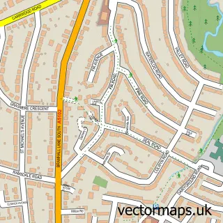
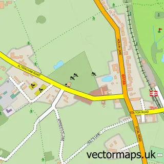
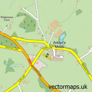
This Woodford street map is a detailed vector street map covering a 750m x 750m area. Select a larger area to create and download your own vector street map of Woodford.
The 750-metre map sample for Woodford covers 229 mapped buildings and approximately 4.0 km of road detail, of which 3 named roads are named. The immediate area includes 2 GP surgeries within 2 miles, 1 pub and 4 MOT stations within 2 miles. The wider area around Woodford features 1 tourism point of interest, 2 food and drink venues and 1 hotel. To create a larger or custom map of Woodford, the map builder lets you define your own coverage area and download editable SVG, PDF and PNG files.
Create a larger editable map of Woodford
Choose any area you need and generate a high-quality vector map instantly. Perfect for print, planning, design, business and personal use.

This Woodford street map in Greater Manchester is available as downloadable SVG, PDF and PNG map files, or as a printed map for planning, business, display, education, local information and design work. You can also create a larger custom map area using the map selector.
What this Woodford map sample shows
Woodford lies within Stockport District (B) parish, part of Bramhall South And Woodford ward in the Stockport District (B) local authority area. The postcode geography for this area includes the SK postcode area, the SK7 postcode district and the SK7 1 postcode sector. Residents fall under the Nhs Greater Manchester Integrated Care Board for NHS services.
Local features near Woodford
Within 2 milesAmenities and services in and around Woodford.
Administrative and postcode information for Woodford
Woodford lies within Stockport District (B) parish, part of Bramhall South And Woodford ward in the Stockport District (B) local authority area. The postcode geography for this area includes the SK postcode area, the SK7 postcode district and the SK7 1 postcode sector. Residents fall under the Nhs Greater Manchester Integrated Care Board for NHS services.
Nearby street map samples around Woodford

More street maps in Greater Manchester
750 metre map area coverage
Boundary, postcode and point of interest information for the 750m x 750m rectangle centred on this sample map.
Boundaries containing map centre
Constituency: Cheadle Boro Const
District: Stockport District (B)
Icb: NHS Greater Manchester ICB
Police Force: greater manchester
Postcode District: SK7
Postcode Sector: SK7 1
Ward: Bramhall South & Woodford Ward
Nearby boundaries intersecting sample
No additional intersecting boundaries found.
Postcode coverage
POI category counts
Nursery And Gardening: 4
Airport: 3
Real Estate: 3
Animal Shelter: 2
Convenience Store: 2
Hair Salon: 2
Home Developer: 2
Advertising Agency: 1
Arts And Entertainment: 1
Barber: 1
Sample points of interest
- Onside Creative Ltd
- British Aerospace Regional Aircraft
- Woodford Airport
- Woodford Airport
- Cottage Cattery
- Flora Cottage
- Woodford
- Barbiere Male Grooming
- Être Belle Cheshire
- Bae woodford
- Woodford Community Centre
- Budgens Chester Road
Create a larger editable map of Woodford
This sample shows only a 750 metre area. To create a larger map of Woodford, use our map builder to choose your own coverage area, add titles and download editable SVG, PDF and PNG files.
Create a custom map of Woodford