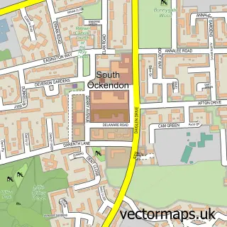
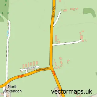
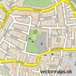
This Aveley street map is a detailed vector street map covering a 750m x 750m area. Select a larger area to create and download your own vector street map of Aveley.
The 750-metre map sample for Aveley covers 540 mapped buildings and approximately 19.8 km of road detail, of which 41 named roads are named. The immediate area includes 1 school, 1 GP surgery, with 5 within 2 miles, 3 pubs and 1 MOT station, with 11 within 2 miles. The wider area around Aveley features 2 tourism points of interest, 7 food and drink venues and 1 hotel. To create a larger or custom map of Aveley, the map builder lets you define your own coverage area and download editable SVG, PDF and PNG files.
Create a larger editable map of Aveley
Choose any area you need and generate a high-quality vector map instantly. Perfect for print, planning, design, business and personal use.

This Aveley street map in Essex is available as downloadable SVG, PDF and PNG map files, or as a printed map for planning, business, display, education, local information and design work. You can also create a larger custom map area using the map selector.
What this Aveley map sample shows
Aveley lies within Thurrock (B) parish, part of Aveley And Uplands ward in the Thurrock (B) local authority area. The postcode geography for this area includes the RM postcode area, the RM15 postcode district and the RM15 4 postcode sector. Residents fall under the Nhs Mid And South Essex Integrated Care Board for NHS services.
Local features near Aveley
Within 2 milesAmenities and services in and around Aveley.
Administrative and postcode information for Aveley
Aveley lies within Thurrock (B) parish, part of Aveley And Uplands ward in the Thurrock (B) local authority area. The postcode geography for this area includes the RM postcode area, the RM15 postcode district and the RM15 4 postcode sector. Residents fall under the Nhs Mid And South Essex Integrated Care Board for NHS services.
Nearby street map samples around Aveley

More street maps in Essex
750 metre map area coverage
Boundary, postcode and point of interest information for the 750m x 750m rectangle centred on this sample map.
Boundaries containing map centre
Constituency: Thurrock Boro Const
District: Thurrock (B)
Icb: NHS Essex ICB
Police Force: essex
Postcode District: RM15
Postcode Sector: RM15 4
Ward: Aveley and Uplands Ward
Nearby boundaries intersecting sample
No additional intersecting boundaries found.
Postcode coverage
POI category counts
Church Cathedral: 4
Community Center: 4
Gas Station: 4
Assisted Living Facility: 3
Beauty Salon: 3
Chinese Restaurant: 3
Coffee Shop: 3
Post Office: 3
Pub: 3
Supermarket: 3
Sample points of interest
- Aveley: St Michael
- Eldaron
- Aveley House
- Breakway East Living
- Meadow View Care
- MFG - Aveley (MRH)
- The Cooperative Food Aveley, Aveley
- EMF Wiring Solutions
- Mint Upholstery
- Aveley Garage & M.O.T. Centre
- Aveley Tyre & Battery Centre
- Liva's
Create a larger editable map of Aveley
This sample shows only a 750 metre area. To create a larger map of Aveley, use our map builder to choose your own coverage area, add titles and download editable SVG, PDF and PNG files.
Create a custom map of Aveley