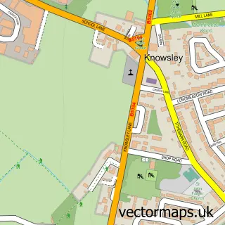
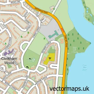
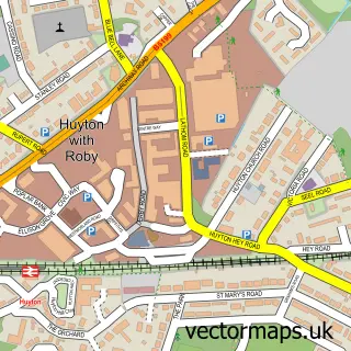
This Prescot street map is a detailed vector street map covering a 750m x 750m area. Select a larger area to create and download your own vector street map of Prescot.
The 750-metre map sample for Prescot covers 352 mapped buildings and approximately 23.4 km of road detail, of which 56 named roads are named. The immediate area includes 2 GP surgeries, with 13 within 2 miles, 10 pubs and 3 MOT stations, with 20 within 2 miles. The wider area around Prescot features 5 tourism points of interest and 25 food and drink venues. To create a larger or custom map of Prescot, the map builder lets you define your own coverage area and download editable SVG, PDF and PNG files.
Create a larger editable map of Prescot
Choose any area you need and generate a high-quality vector map instantly. Perfect for print, planning, design, business and personal use.

This Prescot street map in Merseyside is available as downloadable SVG, PDF and PNG map files, or as a printed map for planning, business, display, education, local information and design work. You can also create a larger custom map area using the map selector.
What this Prescot map sample shows
Prescot lies within Prescot Cp parish, part of Prescot North ward in the Knowsley District (B) local authority area. The postcode geography for this area includes the L postcode area, the L34 postcode district and the L34 2 postcode sector. Residents fall under the Nhs Cheshire And Merseyside Integrated Care Board for NHS services.
Local features near Prescot
Within 2 milesAmenities and services in and around Prescot.
Administrative and postcode information for Prescot
The local authority covering Prescot is Knowsley District (B), within the county of Merseyside. The settlement lies within Prescot North ward and Prescot Cp civil parish. The L34 postcode district and L34 2 postcode sector serve the immediate area. NHS provision in the area is delivered through Mersey And West Lancashire Teaching Hospitals Nhs Trust.
Nearby street map samples around Prescot

More street maps in Merseyside
750 metre map area coverage
Boundary, postcode and point of interest information for the 750m x 750m rectangle centred on this sample map.
Boundaries containing map centre
Constituency: Knowsley Boro Const
District: Knowsley District (B)
Icb: NHS Cheshire and Merseyside ICB
Parish: Prescot CP
Police Force: merseyside
Postcode District: L34
Postcode Sector: L34 5
Ward: Prescot North Ward
Nearby boundaries intersecting sample
Postcode Sector: L34 1, L34 2, L34 3, L34 6
Postcode coverage
POI category counts
Hair Salon: 12
Beauty Salon: 11
Pub: 10
Cafe: 8
Bakery: 7
Banks: 7
Legal Services: 6
Professional Services: 6
Supermarket: 6
Womens Clothing Store: 6
Sample points of interest
- Butterworth Barlow
- Mark A Salmon & Company
- Porter Associates
- Sergents Accountants
- Reel Time
- St Mary C Of E Church
- Oxfam
- Themis Freelance Security
- John Joseph Powell Memorial Nursing Home
- Hull University Union
- Morrisons Daily - Prescot, Prescot
- Acclaim Audio Visual Ltd
Create a larger editable map of Prescot
This sample shows only a 750 metre area. To create a larger map of Prescot, use our map builder to choose your own coverage area, add titles and download editable SVG, PDF and PNG files.
Create a custom map of Prescot